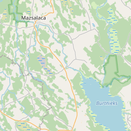
Land unit (cadastre designation: 96480090031)
Cadastre designation: 96480090031
Address: "Penči", Burtnieku pagasts, Valmieras novads, LV-4206
Cadastre designation of real estate | |
|---|---|
Cadastral object type | Cadastral object type: Land unit |
Address | Address: "Penči", Burtnieku pagasts, Valmieras novads, LV-4206 |
Cadastre number of the real estate in which this land unit is included | Cadastre number of the real estate in which this land unit is included: 96480090031 |
Address | |
|---|---|
Address ID | Address ID: 102812881 |
Companies registered at the address | Companies registered at the address: 0 |
Departments registered at the address | Departments registered at the address: 0 |
Institutions registered at the address | Institutions registered at the address: 0 |
Real estate registered at the address | |
Transactions with real estate at the address | Transactions with real estate at the address: 0 |
|
|
|
{"7201060110":{"name":"<div class='color_dot' style='background-color: #00ffff'><\/div><span>Measured land unit<\/span>","featureColor":"#00ffff","features":{"type":"FeatureCollection","features":[{"type":"Feature","geometry":{"type":"Polygon","coordinates":[[[25.323833802,57.652408121],[25.323843053,57.65235062],[25.323883428,57.65228176],[25.323940493,57.65222347],[25.323971958,57.652233894],[25.325264662,57.652675734],[25.32558471,57.652840463],[25.327253604,57.653312478],[25.329600871,57.655789843],[25.327116783,57.655160218],[25.326866387,57.655095468],[25.323954113,57.654337064],[25.323936325,57.654305583],[25.323946649,57.65427016],[25.324141478,57.653889571],[25.324197305,57.653761815],[25.324397164,57.653345068],[25.324498876,57.653126816],[25.324583065,57.652918387],[25.324549788,57.652877564],[25.324386304,57.652788964],[25.324147048,57.652671565],[25.323894207,57.652544138],[25.323845104,57.652497111],[25.323833802,57.652408121]]]},"crs":{"type":"name","properties":{"name":"urn:ogc:def:crs:EPSG:3059"}},"properties":{"style":{"color":"#00ffff","dashArray":"0","weight":1},"name":"Land","object_type":"Parcel","parcel_code":"96480130046","code":null,"surveyor":null,"address":"","ownership":"<span>Owner - Natural person<br><\/span>","pro_cadastre_nr":"96480090031"}},{"type":"Feature","geometry":{"type":"Polygon","coordinates":[[[25.258140823,57.655002127],[25.259091046,57.654181735],[25.26219733,57.654830153],[25.269381552,57.656332897],[25.2678644,57.65737028],[25.267744289,57.657384878],[25.261563243,57.655927467],[25.258140823,57.655002127]]]},"crs":{"type":"name","properties":{"name":"urn:ogc:def:crs:EPSG:3059"}},"properties":{"style":{"color":"#00ffff","dashArray":"0","weight":1},"name":"Land","object_type":"Parcel","parcel_code":"96480090044","code":null,"surveyor":null,"address":"","ownership":"<span>Owner - Natural person<br><\/span>","pro_cadastre_nr":"96480090031"}},{"type":"Feature","geometry":{"type":"Polygon","coordinates":[[[25.265634263,57.67121793],[25.265678639,57.671177393],[25.266267122,57.670668207],[25.266680343,57.67031262],[25.266769418,57.670347186],[25.268599951,57.671057494],[25.270142104,57.671656941],[25.27022518,57.671688565],[25.269784541,57.67198831],[25.269008499,57.672496052],[25.268181544,57.672184864],[25.267437168,57.671902229],[25.267376713,57.671878812],[25.265718079,57.67124972],[25.265634263,57.67121793]]]},"crs":{"type":"name","properties":{"name":"urn:ogc:def:crs:EPSG:3059"}},"properties":{"style":{"color":"#00ffff","dashArray":"0","weight":1},"name":"Land","object_type":"Parcel","parcel_code":"96480090031","code":null,"surveyor":null,"address":"\"Pen\u010di\", Burtnieku pag., Valmieras nov., LV-4206","ownership":"<span>Owner - Natural person<br><\/span>","pro_cadastre_nr":"96480090031"}}]}},"5201011310":{"name":"<div class='color_dot' style='background-color: #960096'><\/div><span>Vectorized building<\/span>","featureColor":"#960096","features":{"type":"FeatureCollection","features":[{"type":"Feature","geometry":{"type":"Polygon","coordinates":[[[25.268133498,57.671742748],[25.267971906,57.671682795],[25.268143894,57.671549715],[25.268305486,57.671609668],[25.268133498,57.671742748]]]},"crs":{"type":"name","properties":{"name":"urn:ogc:def:crs:EPSG:3059"}},"properties":{"style":{"color":"#960096","dashArray":"0","weight":2},"name":"Building","object_type":"Building","parcel_code":"96480090031","code":"96480090031002","surveyor":null,"address":"\"Pen\u010di\", Burtnieku pag., Valmieras nov., LV-4206","ownership":"<span>Owner - Natural person<br><\/span>","pro_cadastre_nr":"96480090031"}},{"type":"Feature","geometry":{"type":"Polygon","coordinates":[[[25.268520162,57.671365268],[25.268348765,57.671307309],[25.268496619,57.671181765],[25.268668032,57.671239715],[25.268520162,57.671365268]]]},"crs":{"type":"name","properties":{"name":"urn:ogc:def:crs:EPSG:3059"}},"properties":{"style":{"color":"#960096","dashArray":"0","weight":2},"name":"Building","object_type":"Building","parcel_code":"96480090031","code":"96480090031001","surveyor":null,"address":"\"Pen\u010di\", Burtnieku pag., Valmieras nov., LV-4206","ownership":"<span>Owner - Natural person<br><\/span>","pro_cadastre_nr":"96480090031"}},{"type":"Feature","geometry":{"type":"Polygon","coordinates":[[[25.267946658,57.671462881],[25.267831457,57.671411977],[25.267903265,57.671365325],[25.268018466,57.671416229],[25.267946658,57.671462881]]]},"crs":{"type":"name","properties":{"name":"urn:ogc:def:crs:EPSG:3059"}},"properties":{"style":{"color":"#960096","dashArray":"0","weight":2},"name":"Building","object_type":"Building","parcel_code":"96480090031","code":"96480090031003","surveyor":null,"address":"\"Pen\u010di\", Burtnieku pag., Valmieras nov., LV-4206","ownership":"<span>Owner - Natural person<br><\/span>","pro_cadastre_nr":"96480090031"}},{"type":"Feature","geometry":{"type":"Polygon","coordinates":[[[25.267946658,57.671462881],[25.267831457,57.671411977],[25.267903265,57.671365325],[25.268018466,57.671416229],[25.267946658,57.671462881]]]},"crs":{"type":"name","properties":{"name":"urn:ogc:def:crs:EPSG:3059"}},"properties":{"style":{"color":"#960096","dashArray":"0","weight":2},"name":"Building","object_type":"Building","parcel_code":"96480090031","code":"96480090031003","surveyor":null,"address":"\"Pen\u010di\", Burtnieku pag., Valmieras nov., LV-4206","ownership":"<span>Owner - Natural person<br><\/span>","pro_cadastre_nr":"96480090031"}},{"type":"Feature","geometry":{"type":"Polygon","coordinates":[[[25.268133498,57.671742748],[25.267971906,57.671682795],[25.268143894,57.671549715],[25.268305486,57.671609668],[25.268133498,57.671742748]]]},"crs":{"type":"name","properties":{"name":"urn:ogc:def:crs:EPSG:3059"}},"properties":{"style":{"color":"#960096","dashArray":"0","weight":2},"name":"Building","object_type":"Building","parcel_code":"96480090031","code":"96480090031002","surveyor":null,"address":"\"Pen\u010di\", Burtnieku pag., Valmieras nov., LV-4206","ownership":"<span>Owner - Natural person<br><\/span>","pro_cadastre_nr":"96480090031"}},{"type":"Feature","geometry":{"type":"Polygon","coordinates":[[[25.268520162,57.671365268],[25.268348765,57.671307309],[25.268496619,57.671181765],[25.268668032,57.671239715],[25.268520162,57.671365268]]]},"crs":{"type":"name","properties":{"name":"urn:ogc:def:crs:EPSG:3059"}},"properties":{"style":{"color":"#960096","dashArray":"0","weight":2},"name":"Building","object_type":"Building","parcel_code":"96480090031","code":"96480090031001","surveyor":null,"address":"\"Pen\u010di\", Burtnieku pag., Valmieras nov., LV-4206","ownership":"<span>Owner - Natural person<br><\/span>","pro_cadastre_nr":"96480090031"}}]}}}
[]
https://tile.openstreetmap.org/{z}/{x}/{y}.png|© OpenStreetMap contributors|minZoom: 7|maxZoom: 19
|
Land unit data updated: 10.01.2025.
Data source and license: Cadastre Information System open text and spatial data, Real Estate Market Database open data, open data license Creative Commons Attribution, OpenStreetMap


