Land unit (cadastre designation: 90110010716)
Cadastre designation: 90110010716
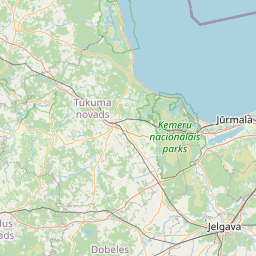
Address: "Radiotornis", Kandava, Tukuma novads, LV-3120
Cadastre designation of real estate | |
|---|---|
Cadastral object type | Cadastral object type: Land unit |
Address | Address: "Radiotornis", Kandava, Tukuma novads, LV-3120 |
Cadastre number of the real estate in which this land unit is included | Cadastre number of the real estate in which this land unit is included: 90110010716 |
Address | |
|---|---|
Address ID | Address ID: 104374864 |
Companies registered at the address | Companies registered at the address: 0 |
Departments registered at the address | Departments registered at the address: 0 |
Institutions registered at the address | Institutions registered at the address: 0 |
Real estate registered at the address | |
Transactions with real estate at the address | Transactions with real estate at the address: 0 |
|
|
    Leaflet | © OpenStreetMap contributors {"7201060110":{"name":"<div class='color_dot' style='background-color: #00ffff'><\/div><span>Measured land unit<\/span>","featureColor":"#00ffff","features":{"type":"FeatureCollection","features":[{"type":"Feature","geometry":{"type":"Polygon","coordinates":[[[22.78258135,57.043633012],[22.782672757,57.043451754],[22.782909749,57.043487694],[22.782817742,57.043668704],[22.78258135,57.043633012]]]},"crs":{"type":"name","properties":{"name":"urn:ogc:def:crs:EPSG:3059"}},"properties":{"style":{"color":"#00ffff","dashArray":"0","weight":1},"name":"Land","object_type":"Parcel","parcel_code":"90110010716","code":null,"surveyor":null,"address":"\"Radiotornis\", Kandava, Tukuma nov., LV-3120","ownership":"<span>Owner - Legal entity<br><\/span>","pro_cadastre_nr":"90110010716"}}]}},"6211003100":{"name":"<div class='color_dot' style='background-color: #878787'><\/div><span>Surveyed engineering building (area)<\/span>","featureColor":"#878787","features":{"type":"FeatureCollection","features":[{"type":"Feature","geometry":{"type":"Polygon","coordinates":[[[22.782661602,57.043561496],[22.782693468,57.043501844],[22.782802223,57.043518309],[22.782771257,57.04357664],[22.782661602,57.043561496]]]},"crs":{"type":"name","properties":{"name":"urn:ogc:def:crs:EPSG:3059"}},"properties":{"style":{"color":"#878787","dashArray":"0","weight":1},"name":"Engineering buildings","object_type":"EngineeringStructurePoly","parcel_code":"90110010716","code":"90110010716001","surveyor":null,"address":"\"Radiotornis\", Kandava, Tukuma nov., LV-3120","ownership":"<span>Owner - Legal entity<br><\/span>","pro_cadastre_nr":"90110010716"}},{"type":"Feature","geometry":{"type":"Polygon","coordinates":[[[22.782661602,57.043561496],[22.782693468,57.043501844],[22.782802223,57.043518309],[22.782771257,57.04357664],[22.782661602,57.043561496]]]},"crs":{"type":"name","properties":{"name":"urn:ogc:def:crs:EPSG:3059"}},"properties":{"style":{"color":"#878787","dashArray":"0","weight":1},"name":"Engineering buildings","object_type":"EngineeringStructurePoly","parcel_code":"90110010716","code":"90110010716001","surveyor":null,"address":"\"Radiotornis\", Kandava, Tukuma nov., LV-3120","ownership":"<span>Owner - Legal entity<br><\/span>","pro_cadastre_nr":"90110010716"}}]}},"5201011110":{"name":"<div class='color_dot' style='background-color: #ff0000'><\/div><span>Measured building<\/span>","featureColor":"#ff0000","features":{"type":"FeatureCollection","features":[{"type":"Feature","geometry":{"type":"Polygon","coordinates":[[[22.782709076,57.043486768],[22.782715815,57.043472207],[22.78274284,57.043475911],[22.782736101,57.043490471],[22.782709076,57.043486768]]]},"crs":{"type":"name","properties":{"name":"urn:ogc:def:crs:EPSG:3059"}},"properties":{"style":{"color":"#ff0000","dashArray":"0","weight":1},"name":"Building","object_type":"Building","parcel_code":"90110010716","code":"90110010716003","surveyor":null,"address":"\"Radiotornis\", Kandava, Tukuma nov., LV-3120","ownership":null,"pro_cadastre_nr":null}},{"type":"Feature","geometry":{"type":"Polygon","coordinates":[[[22.782746086,57.043492078],[22.782755485,57.043472808],[22.782806929,57.043480253],[22.78279753,57.043499532],[22.782746086,57.043492078]]]},"crs":{"type":"name","properties":{"name":"urn:ogc:def:crs:EPSG:3059"}},"properties":{"style":{"color":"#ff0000","dashArray":"0","weight":1},"name":"Building","object_type":"Building","parcel_code":"90110010716","code":"90110010716002","surveyor":null,"address":"\"Radiotornis\", Kandava, Tukuma nov., LV-3120","ownership":null,"pro_cadastre_nr":null}}]}}}
[]
https://tile.openstreetmap.org/{z}/{x}/{y}.png|© OpenStreetMap contributors|minZoom: 7|maxZoom: 19
|
Land unit data updated: 23.01.2025.
Data source and license: Cadastre Information System open text and spatial data, Real Estate Market Database open data, open data license Creative Commons Attribution, OpenStreetMap