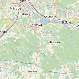
Land unit (cadastre designation: 80250070155)
Cadastre designation: 80250070155
Administrative area: Ķekavas novads
Cadastre designation of real estate | |
|---|---|
Cadastral object type | Cadastral object type: Land unit |
Administrative area | |
Cadastre number of the real estate in which this land unit is included | Cadastre number of the real estate in which this land unit is included: 80250110667 |
|
|
|
{"7201060310":{"name":"<div class='color_dot' style='background-color: #00ffff'><\/div><span>Projected land unit<\/span>","featureColor":"#00ffff","features":{"type":"FeatureCollection","features":[{"type":"Feature","geometry":{"type":"Polygon","coordinates":[[[24.376711641,56.707306485],[24.376833032,56.707231228],[24.377925117,56.707619667],[24.377903773,56.707654249],[24.376711641,56.707306485]]]},"crs":{"type":"name","properties":{"name":"urn:ogc:def:crs:EPSG:3059"}},"properties":{"style":{"color":"#00ffff","dashArray":"2,4","weight":1},"name":"Land","object_type":"Parcel","parcel_code":"80250120138","code":null,"surveyor":null,"address":"","ownership":"<span>Legal owner - Municipality<br><\/span>","pro_cadastre_nr":"80250110667"}},{"type":"Feature","geometry":{"type":"Polygon","coordinates":[[[24.367816414,56.67031561],[24.368519267,56.669043899],[24.368611114,56.669032001],[24.367891428,56.670334183],[24.367816414,56.67031561]]]},"crs":{"type":"name","properties":{"name":"urn:ogc:def:crs:EPSG:3059"}},"properties":{"style":{"color":"#00ffff","dashArray":"2,4","weight":1},"name":"Land","object_type":"Parcel","parcel_code":"80250120090","code":null,"surveyor":null,"address":"","ownership":"<span>Legal owner - Municipality<br><\/span>","pro_cadastre_nr":"80250110667"}},{"type":"Feature","geometry":{"type":"Polygon","coordinates":[[[24.299393783,56.695552144],[24.299424377,56.695520528],[24.299539624,56.695401456],[24.299640245,56.695410297],[24.299718755,56.6954436],[24.301290403,56.696110527],[24.301188036,56.696320936],[24.301125499,56.696329407],[24.299430469,56.69557015],[24.299393783,56.695552144]]]},"crs":{"type":"name","properties":{"name":"urn:ogc:def:crs:EPSG:3059"}},"properties":{"style":{"color":"#00ffff","dashArray":"2,4","weight":1},"name":"Land","object_type":"Parcel","parcel_code":"80250110674","code":null,"surveyor":null,"address":"","ownership":"<span>Legal owner - Municipality<br><\/span>","pro_cadastre_nr":"80250110667"}},{"type":"Feature","geometry":{"type":"Polygon","coordinates":[[[24.289728091,56.688822654],[24.289784584,56.688674835],[24.289837786,56.688646852],[24.293254846,56.689905965],[24.293256859,56.690122924],[24.289728091,56.688822654]]]},"crs":{"type":"name","properties":{"name":"urn:ogc:def:crs:EPSG:3059"}},"properties":{"style":{"color":"#00ffff","dashArray":"2,4","weight":1},"name":"Land","object_type":"Parcel","parcel_code":"80250110419","code":null,"surveyor":null,"address":"","ownership":"<span>Legal owner - Municipality<br><\/span>","pro_cadastre_nr":"80250110667"}},{"type":"Feature","geometry":{"type":"Polygon","coordinates":[[[24.287328408,56.687914998],[24.287608132,56.687813364],[24.287796163,56.687911574],[24.288509322,56.68816276],[24.28827126,56.68829225],[24.287593965,56.688053682],[24.287328408,56.687914998]]]},"crs":{"type":"name","properties":{"name":"urn:ogc:def:crs:EPSG:3059"}},"properties":{"style":{"color":"#00ffff","dashArray":"2,4","weight":1},"name":"Land","object_type":"Parcel","parcel_code":"80250110400","code":null,"surveyor":null,"address":"","ownership":"<span>Legal owner - Municipality<br><\/span>","pro_cadastre_nr":"80250110667"}},{"type":"Feature","geometry":{"type":"Polygon","coordinates":[[[24.319615337,56.709777575],[24.319852529,56.709665467],[24.319947724,56.709747884],[24.322424043,56.712788979],[24.322491426,56.71287267],[24.322260505,56.713035607],[24.322201903,56.712968208],[24.319637051,56.709822502],[24.319615337,56.709777575]]]},"crs":{"type":"name","properties":{"name":"urn:ogc:def:crs:EPSG:3059"}},"properties":{"style":{"color":"#00ffff","dashArray":"2,4","weight":1},"name":"Land","object_type":"Parcel","parcel_code":"80250080223","code":null,"surveyor":null,"address":"","ownership":"<span>Legal owner - Municipality<br><\/span>","pro_cadastre_nr":"80250110667"}},{"type":"Feature","geometry":{"type":"Polygon","coordinates":[[[24.285320885,56.723071895],[24.285351007,56.72294111],[24.285400587,56.722725831],[24.285447553,56.722879528],[24.285404538,56.723066259],[24.285654193,56.723420571],[24.285912772,56.723787564],[24.285835378,56.723802053],[24.285320885,56.723071895]]]},"crs":{"type":"name","properties":{"name":"urn:ogc:def:crs:EPSG:3059"}},"properties":{"style":{"color":"#00ffff","dashArray":"2,4","weight":1},"name":"Land","object_type":"Parcel","parcel_code":"80250070511","code":null,"surveyor":null,"address":"","ownership":"<span>Legal owner - Municipality<br><\/span>","pro_cadastre_nr":"80250110667"}},{"type":"Feature","geometry":{"type":"Polygon","coordinates":[[[24.286362466,56.724632208],[24.286493751,56.724522805],[24.286547912,56.724598855],[24.286626981,56.724709868],[24.287517888,56.726391683],[24.287313307,56.726424147],[24.286441157,56.724745162],[24.286411055,56.724701955],[24.286362466,56.724632208]]]},"crs":{"type":"name","properties":{"name":"urn:ogc:def:crs:EPSG:3059"}},"properties":{"style":{"color":"#00ffff","dashArray":"2,4","weight":1},"name":"Land","object_type":"Parcel","parcel_code":"80250070510","code":null,"surveyor":null,"address":"","ownership":"<span>Legal owner - Municipality<br><\/span>","pro_cadastre_nr":"80250110667"}},{"type":"Feature","geometry":{"type":"Polygon","coordinates":[[[24.283788428,56.722007823],[24.285371197,56.721969298],[24.28536913,56.722037293],[24.283746715,56.722053799],[24.283788428,56.722007823]]]},"crs":{"type":"name","properties":{"name":"urn:ogc:def:crs:EPSG:3059"}},"properties":{"style":{"color":"#00ffff","dashArray":"2,4","weight":1},"name":"Land","object_type":"Parcel","parcel_code":"80250070162","code":null,"surveyor":null,"address":"","ownership":"<span>Legal owner - Municipality<br><\/span>","pro_cadastre_nr":"80250110667"}},{"type":"Feature","geometry":{"type":"Polygon","coordinates":[[[24.241120882,56.715040392],[24.241464794,56.715084502],[24.24186346,56.716336404],[24.24188015,56.716388819],[24.241585767,56.716432468],[24.241577055,56.716406405],[24.241128677,56.715063735],[24.241120882,56.715040392]]]},"crs":{"type":"name","properties":{"name":"urn:ogc:def:crs:EPSG:3059"}},"properties":{"style":{"color":"#00ffff","dashArray":"2,4","weight":1},"name":"Land","object_type":"Parcel","parcel_code":"80250070155","code":null,"surveyor":null,"address":"","ownership":"<span>Legal owner - Municipality<br><\/span>","pro_cadastre_nr":"80250110667"}},{"type":"Feature","geometry":{"type":"Polygon","coordinates":[[[24.318502429,56.774502746],[24.318970124,56.774697409],[24.31945899,56.774900891],[24.319702718,56.774897239],[24.319879525,56.77501142],[24.31950756,56.775016991],[24.319656324,56.775233544],[24.31987247,56.775547766],[24.319823264,56.775603386],[24.319603903,56.775284338],[24.319433851,56.77503698],[24.318932618,56.774828355],[24.318843507,56.774760925],[24.318502429,56.774502746]]]},"crs":{"type":"name","properties":{"name":"urn:ogc:def:crs:EPSG:3059"}},"properties":{"style":{"color":"#00ffff","dashArray":"2,4","weight":1},"name":"Land","object_type":"Parcel","parcel_code":"80250020128","code":null,"surveyor":null,"address":"","ownership":"<span>Legal owner - Municipality<br><\/span>","pro_cadastre_nr":"80250110667"}},{"type":"Feature","geometry":{"type":"Polygon","coordinates":[[[24.268856257,56.785190196],[24.270907557,56.782929718],[24.2711344,56.782941731],[24.271317648,56.7829975],[24.269480243,56.785054972],[24.269422349,56.785102595],[24.268856257,56.785190196]]]},"crs":{"type":"name","properties":{"name":"urn:ogc:def:crs:EPSG:3059"}},"properties":{"style":{"color":"#00ffff","dashArray":"2,4","weight":1},"name":"Land","object_type":"Parcel","parcel_code":"80250010109","code":null,"surveyor":null,"address":"","ownership":"<span>Legal owner - Municipality<br><\/span>","pro_cadastre_nr":"80250110667"}}]}}}
{"7201060310":{"name":"<div class='color_dot' style='background-color: #00ffff'><\/div><span>Projected land unit<\/span>","featureColor":"#00ffff","features":{"type":"FeatureCollection","features":[{"type":"Feature","geometry":{"type":"Polygon","coordinates":[[[24.299393783,56.695552144],[24.299424377,56.695520528],[24.299539624,56.695401456],[24.299742746,56.695454431],[24.301290403,56.696110527],[24.301188036,56.696320936],[24.301125499,56.696329407],[24.299430469,56.69557015],[24.299393783,56.695552144]]]},"crs":{"type":"name","properties":{"name":"urn:ogc:def:crs:EPSG:3059"}},"properties":{"style":{"color":"#00ffff","dashArray":"2,4","weight":1},"name":"Land","object_type":"Parcel","parcel_code":"80250110674","code":null,"surveyor":null,"address":"","ownership":"<span>Legal owner - Municipality<br><\/span>","pro_cadastre_nr":"80250110667"}},{"type":"Feature","geometry":{"type":"Polygon","coordinates":[[[24.285157724,56.723101807],[24.285365113,56.722272834],[24.285393936,56.722738756],[24.285405176,56.722800989],[24.285366912,56.723069247],[24.285910832,56.723785934],[24.285730783,56.723808726],[24.285157724,56.723101807]]]},"crs":{"type":"name","properties":{"name":"urn:ogc:def:crs:EPSG:3059"}},"properties":{"style":{"color":"#00ffff","dashArray":"2,4","weight":1},"name":"Land","object_type":"Parcel","parcel_code":"80250070511","code":null,"surveyor":null,"address":"","ownership":"<span>Legal owner - Municipality<br><\/span>","pro_cadastre_nr":"80250110667"}},{"type":"Feature","geometry":{"type":"Polygon","coordinates":[[[24.283764328,56.722031847],[24.283838047,56.721939945],[24.285358164,56.721914149],[24.285344088,56.72202533],[24.283764328,56.722031847]]]},"crs":{"type":"name","properties":{"name":"urn:ogc:def:crs:EPSG:3059"}},"properties":{"style":{"color":"#00ffff","dashArray":"2,4","weight":1},"name":"Land","object_type":"Parcel","parcel_code":"80250070162","code":null,"surveyor":null,"address":"","ownership":"<span>Legal owner - Municipality<br><\/span>","pro_cadastre_nr":"80250110667"}}]}}}
https://tile.openstreetmap.org/{z}/{x}/{y}.png|© OpenStreetMap contributors|minZoom: 7|maxZoom: 19
|
Land unit data updated: 23.01.2025.
Data source and license: Cadastre Information System open text and spatial data, Real Estate Market Database open data, open data license Creative Commons Attribution, OpenStreetMap

