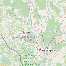
Land unit (cadastre designation: 44620020126)
Cadastre designation: 44620020126
Address: "Skalbes", Ivbuļi, Kalupes pagasts, Augšdaugavas novads, LV-5450
Cadastre designation of real estate | |
|---|---|
Cadastral object type | Cadastral object type: Land unit |
Address | Address: "Skalbes", Ivbuļi, Kalupes pagasts, Augšdaugavas novads, LV-5450 |
Cadastre number of the real estate in which this land unit is included | Cadastre number of the real estate in which this land unit is included: 44620020126 |
Address | |
|---|---|
Address ID | Address ID: 104565677 |
Companies registered at the address | Companies registered at the address: 0 |
Departments registered at the address | Departments registered at the address: 0 |
Institutions registered at the address | Institutions registered at the address: 0 |
Real estate registered at the address | |
Transactions with real estate at the address | Transactions with real estate at the address: 0 |
|
|
|
{"7201060110":{"name":"<div class='color_dot' style='background-color: #00ffff'><\/div><span>Measured land unit<\/span>","featureColor":"#00ffff","features":{"type":"FeatureCollection","features":[{"type":"Feature","geometry":{"type":"Polygon","coordinates":[[[26.484480224,56.090741207],[26.484551271,56.090291465],[26.484729536,56.089947087],[26.485278546,56.089005351],[26.485348956,56.089011519],[26.487286566,56.089181238],[26.487382167,56.089189611],[26.488554826,56.089895995],[26.487895298,56.090751154],[26.487823,56.090751182],[26.484552811,56.090741427],[26.484480224,56.090741207]]]},"crs":{"type":"name","properties":{"name":"urn:ogc:def:crs:EPSG:3059"}},"properties":{"style":{"color":"#00ffff","dashArray":"0","weight":1},"name":"Land","object_type":"Parcel","parcel_code":"44620050163","code":null,"surveyor":null,"address":"","ownership":"<span>Owner - Natural person<br><\/span>","pro_cadastre_nr":"44620020126"}},{"type":"Feature","geometry":{"type":"Polygon","coordinates":[[[26.495296242,56.100477001],[26.495672059,56.099748474],[26.495995241,56.099288404],[26.496959052,56.098089016],[26.499578094,56.09834414],[26.499147724,56.100193927],[26.495296242,56.100477001]]]},"crs":{"type":"name","properties":{"name":"urn:ogc:def:crs:EPSG:3059"}},"properties":{"style":{"color":"#00ffff","dashArray":"0","weight":1},"name":"Land","object_type":"Parcel","parcel_code":"44620020127","code":null,"surveyor":null,"address":"","ownership":"<span>Owner - Natural person<br><\/span>","pro_cadastre_nr":"44620020126"}},{"type":"Feature","geometry":{"type":"Polygon","coordinates":[[[26.490232759,56.098135208],[26.491173243,56.097211865],[26.494123427,56.097999908],[26.495617741,56.096823649],[26.496753616,56.097973146],[26.495782892,56.099239696],[26.495479512,56.09968946],[26.495119643,56.100422203],[26.492358529,56.099929018],[26.492902108,56.099021963],[26.490232759,56.098135208]]]},"crs":{"type":"name","properties":{"name":"urn:ogc:def:crs:EPSG:3059"}},"properties":{"style":{"color":"#00ffff","dashArray":"0","weight":1},"name":"Land","object_type":"Parcel","parcel_code":"44620020126","code":null,"surveyor":null,"address":"\"Skalbes\", Ivbu\u013ci, Kalupes pag., Aug\u0161daugavas nov., LV-5450","ownership":"<span>Owner - Natural person<br><\/span>","pro_cadastre_nr":"44620020126"}},{"type":"Feature","geometry":{"type":"Polygon","coordinates":[[[26.414554898,56.110339758],[26.417050045,56.109275786],[26.417509876,56.109160905],[26.418588342,56.10984208],[26.418443984,56.109894709],[26.415607739,56.11092857],[26.414554898,56.110339758]]]},"crs":{"type":"name","properties":{"name":"urn:ogc:def:crs:EPSG:3059"}},"properties":{"style":{"color":"#00ffff","dashArray":"0","weight":1},"name":"Land","object_type":"Parcel","parcel_code":"44620010155","code":null,"surveyor":null,"address":"","ownership":"<span>Owner - Natural person<br><\/span>","pro_cadastre_nr":"44620020126"}}]}},"5201011310":{"name":"<div class='color_dot' style='background-color: #960096'><\/div><span>Vectorized building<\/span>","featureColor":"#960096","features":{"type":"FeatureCollection","features":[{"type":"Feature","geometry":{"type":"Polygon","coordinates":[[[26.49507658,56.098788783],[26.495158923,56.098650015],[26.495278176,56.098672123],[26.495198764,56.098811434],[26.49507658,56.098788783]]]},"crs":{"type":"name","properties":{"name":"urn:ogc:def:crs:EPSG:3059"}},"properties":{"style":{"color":"#960096","dashArray":"0","weight":2},"name":"Building","object_type":"Building","parcel_code":"44620020126","code":"44620020126003","surveyor":null,"address":"\"Skalbes\", Ivbu\u013ci, Kalupes pag., Aug\u0161daugavas nov., LV-5450","ownership":null,"pro_cadastre_nr":null}},{"type":"Feature","geometry":{"type":"Polygon","coordinates":[[[26.495582953,56.098534485],[26.495601221,56.098501192],[26.495730057,56.098523277],[26.495711789,56.09855657],[26.495582953,56.098534485]]]},"crs":{"type":"name","properties":{"name":"urn:ogc:def:crs:EPSG:3059"}},"properties":{"style":{"color":"#960096","dashArray":"0","weight":2},"name":"Building","object_type":"Building","parcel_code":"44620020126","code":"44620020126006","surveyor":null,"address":"\"Skalbes\", Ivbu\u013ci, Kalupes pag., Aug\u0161daugavas nov., LV-5450","ownership":null,"pro_cadastre_nr":null}},{"type":"Feature","geometry":{"type":"Polygon","coordinates":[[[26.495046087,56.098991504],[26.495057809,56.098922904],[26.495162052,56.09892849],[26.495150039,56.09899706],[26.495046087,56.098991504]]]},"crs":{"type":"name","properties":{"name":"urn:ogc:def:crs:EPSG:3059"}},"properties":{"style":{"color":"#960096","dashArray":"0","weight":2},"name":"Building","object_type":"Building","parcel_code":"44620020126","code":"44620020126002","surveyor":null,"address":"\"Skalbes\", Ivbu\u013ci, Kalupes pag., Aug\u0161daugavas nov., LV-5450","ownership":null,"pro_cadastre_nr":null}},{"type":"Feature","geometry":{"type":"Polygon","coordinates":[[[26.495046087,56.098991504],[26.495150039,56.09899706],[26.495136792,56.099072665],[26.495033162,56.099067112],[26.495046087,56.098991504]]]},"crs":{"type":"name","properties":{"name":"urn:ogc:def:crs:EPSG:3059"}},"properties":{"style":{"color":"#960096","dashArray":"0","weight":2},"name":"Building","object_type":"Building","parcel_code":"44620020126","code":"44620020126004","surveyor":null,"address":"\"Skalbes\", Ivbu\u013ci, Kalupes pag., Aug\u0161daugavas nov., LV-5450","ownership":null,"pro_cadastre_nr":null}},{"type":"Feature","geometry":{"type":"Polygon","coordinates":[[[26.495169566,56.099094563],[26.495178586,56.09905104],[26.495294227,56.099059308],[26.495285367,56.099102064],[26.495169566,56.099094563]]]},"crs":{"type":"name","properties":{"name":"urn:ogc:def:crs:EPSG:3059"}},"properties":{"style":{"color":"#960096","dashArray":"0","weight":2},"name":"Building","object_type":"Building","parcel_code":"44620020126","code":"44620020126005","surveyor":null,"address":"\"Skalbes\", Ivbu\u013ci, Kalupes pag., Aug\u0161daugavas nov., LV-5450","ownership":null,"pro_cadastre_nr":null}},{"type":"Feature","geometry":{"type":"Polygon","coordinates":[[[26.495453917,56.098974199],[26.495468172,56.098937536],[26.495427005,56.098932068],[26.495442443,56.098892811],[26.495483447,56.098898246],[26.495497066,56.098863196],[26.495638595,56.098880378],[26.495595447,56.09899139],[26.495453917,56.098974199]]]},"crs":{"type":"name","properties":{"name":"urn:ogc:def:crs:EPSG:3059"}},"properties":{"style":{"color":"#960096","dashArray":"0","weight":2},"name":"Building","object_type":"Building","parcel_code":"44620020126","code":"44620020126001","surveyor":null,"address":"\"Skalbes\", Ivbu\u013ci, Kalupes pag., Aug\u0161daugavas nov., LV-5450","ownership":null,"pro_cadastre_nr":null}}]}}}
[]
https://tile.openstreetmap.org/{z}/{x}/{y}.png|© OpenStreetMap contributors|minZoom: 7|maxZoom: 19
|
Land unit data updated: 23.01.2025.
Data source and license: Cadastre Information System open text and spatial data, Real Estate Market Database open data, open data license Creative Commons Attribution, OpenStreetMap

