Building (cadastre designation: 94580050034005)
Cadastre designation: 94580050034005
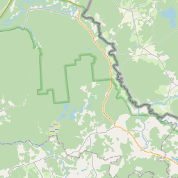
Address: "Bēržu Kalni", Grundzāles pagasts, Smiltenes novads, LV-4713
Cadastre designation of real estate | Cadastre designation of real estate: 94580050034005 |
|---|---|
Cadastral object type | Cadastral object type: Building |
Address | Address: "Bēržu Kalni", Grundzāles pagasts, Smiltenes novads, LV-4713 |
Address | |
|---|---|
Address ID | Address ID: 106688934 |
Companies registered at the address | Companies registered at the address: 0 |
Departments registered at the address | Departments registered at the address: 0 |
Institutions registered at the address | Institutions registered at the address: 0 |
Real estate registered at the address | |
Transactions with real estate at the address | Transactions with real estate at the address: 0 |
|
|
|
{"7201060210":{"name":"<div class='color_dot' style='background-color: #00ffff'><\/div><span>Specified land unit<\/span>","featureColor":"#00ffff","features":{"type":"FeatureCollection","features":[{"type":"Feature","geometry":{"type":"Polygon","coordinates":[[[26.13102551,57.487945376],[26.131085211,57.487934519],[26.134576932,57.487299482],[26.134760612,57.487293407],[26.134831582,57.487285826],[26.136148192,57.48704869],[26.136692927,57.486951134],[26.136907063,57.486920909],[26.139396128,57.486419255],[26.138069684,57.48765393],[26.138054054,57.487724497],[26.138047958,57.487926188],[26.138276053,57.487938001],[26.138739281,57.488959624],[26.139764199,57.491052142],[26.140657685,57.491129035],[26.140988824,57.491164477],[26.142241051,57.491403754],[26.144247841,57.491832149],[26.145504238,57.492096778],[26.147075627,57.491797849],[26.147595496,57.491698945],[26.148238015,57.490377574],[26.14854025,57.490232899],[26.148810178,57.490125983],[26.14997031,57.487836601],[26.150004267,57.487826722],[26.150858917,57.487869476],[26.153563394,57.487983989],[26.154805973,57.487555254],[26.158065263,57.484765194],[26.159319218,57.485086919],[26.163714449,57.484717791],[26.163967319,57.484483297],[26.164188802,57.484154886],[26.164200205,57.483940449],[26.164058246,57.483780581],[26.163830137,57.483589725],[26.163612596,57.483486971],[26.15787789,57.481503149],[26.156271538,57.481244755],[26.155914263,57.481159743],[26.15547754,57.48098368],[26.154531635,57.480656682],[26.153317592,57.480331767],[26.153259787,57.480317569],[26.151253852,57.479824729],[26.149343549,57.479376611],[26.149838523,57.479159773],[26.150509192,57.478865968],[26.150562524,57.478851535],[26.150681598,57.478845641],[26.151211259,57.478904625],[26.157062467,57.479830229],[26.163243131,57.480809881],[26.163554597,57.480851523],[26.16530091,57.480993664],[26.165559407,57.481104212],[26.165748523,57.481299013],[26.165845094,57.481565797],[26.165967559,57.481695654],[26.166412752,57.481710892],[26.167378114,57.48167245],[26.168163936,57.481773596],[26.16956304,57.481786506],[26.170288103,57.481704445],[26.170780315,57.481537315],[26.171235226,57.481305905],[26.171627668,57.48125793],[26.171823764,57.481295769],[26.171978175,57.481415717],[26.172128256,57.481575401],[26.172199575,57.481761682],[26.172202502,57.481923901],[26.172223808,57.482183809],[26.172481922,57.482312132],[26.172880688,57.482474099],[26.173261172,57.482495936],[26.174412272,57.482321774],[26.177133854,57.481973897],[26.177490106,57.481928353],[26.177662547,57.481905795],[26.17781961,57.481885255],[26.17809643,57.481851145],[26.178662734,57.482333356],[26.178668855,57.482338938],[26.178630621,57.482370922],[26.178013585,57.482961544],[26.177516157,57.483579767],[26.177251729,57.483931327],[26.176921902,57.484439977],[26.176769949,57.484805337],[26.176511827,57.485163041],[26.176218132,57.485583052],[26.176163091,57.485720187],[26.176140277,57.485938812],[26.175239763,57.485947538],[26.174583103,57.485953894],[26.170873336,57.485945066],[26.169552216,57.485937386],[26.167521564,57.485945063],[26.166129587,57.485929229],[26.165873021,57.485942882],[26.164349569,57.485965346],[26.163723778,57.485954268],[26.163175213,57.487444389],[26.162744731,57.488578292],[26.162306832,57.489774276],[26.161845412,57.490900861],[26.161520556,57.491552998],[26.161365636,57.491880262],[26.161260486,57.492171001],[26.161371772,57.492362929],[26.159658419,57.494819221],[26.160506482,57.496410103],[26.161066731,57.497399258],[26.1579729,57.497999669],[26.147240748,57.500463713],[26.145474448,57.500835072],[26.14399885,57.499599237],[26.143182725,57.498290183],[26.142933416,57.497835309],[26.142016993,57.496366025],[26.141267328,57.495086489],[26.140979765,57.494608512],[26.14066639,57.494270713],[26.139959774,57.49350534],[26.139250137,57.492743707],[26.138287232,57.491712058],[26.137997591,57.491402326],[26.137811396,57.491311782],[26.135401852,57.490557987],[26.134529192,57.490172505],[26.13352252,57.489710806],[26.132428834,57.489189199],[26.131607407,57.488777546],[26.131373556,57.488544176],[26.131175264,57.488269294],[26.13102551,57.487945376]]]},"crs":{"type":"name","properties":{"name":"urn:ogc:def:crs:EPSG:3059"}},"properties":{"style":{"color":"#00ffff","dashArray":"8,12","weight":1},"name":"Land","object_type":"Parcel","parcel_code":"94580050034","code":null,"surveyor":null,"address":"\"B\u0113r\u017eu Kalni\", Grundz\u0101les pag., Smiltenes nov., LV-4713","ownership":"<span>Owner - Natural person<br><\/span>","pro_cadastre_nr":"94580050034"}}]}},"5201011310":{"name":"<div class='color_dot' style='background-color: #960096'><\/div><span>Vectorized building<\/span>","featureColor":"#960096","features":{"type":"FeatureCollection","features":[{"type":"Feature","geometry":{"type":"Polygon","coordinates":[[[26.160698189,57.491136245],[26.160868716,57.490786439],[26.161151986,57.490826476],[26.160981478,57.491176282],[26.160698189,57.491136245]]]},"crs":{"type":"name","properties":{"name":"urn:ogc:def:crs:EPSG:3059"}},"properties":{"style":{"color":"#960096","dashArray":"0","weight":2},"name":"Building","object_type":"Building","parcel_code":"94580050034","code":"94580050034005","surveyor":null,"address":"\"B\u0113r\u017eu Kalni\", Grundz\u0101les pag., Smiltenes nov., LV-4713","ownership":"<span>The building owner - Legal entity<br><\/span>","pro_cadastre_nr":null}}]}}}
[]
https://tile.openstreetmap.org/{z}/{x}/{y}.png|© OpenStreetMap contributors|minZoom: 7|maxZoom: 19
|

Building data updated: 14.02.2025.
Data source and license: Cadastre Information System open text and spatial data, Real Estate Market Database open data, open data license Creative Commons Attribution, OpenStreetMap