Building (cadastre designation: 17000100030011)
Cadastre designation: 17000100030011
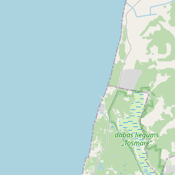
Administrative area: Liepāja
Cadastre designation of real estate | Cadastre designation of real estate: 17000100030011 |
|---|---|
Cadastral object type | Cadastral object type: Building |
Administrative area |
|
|
|
{"7201060110":{"name":"<div class='color_dot' style='background-color: #00ffff'><\/div><span>Measured land unit<\/span>","featureColor":"#00ffff","features":{"type":"FeatureCollection","features":[{"type":"Feature","geometry":{"type":"Polygon","coordinates":[[[20.962119271,56.548981278],[20.963122661,56.545043159],[20.964125811,56.541105028],[20.96479446,56.5384796],[20.965806618,56.534768014],[20.966238765,56.533109736],[20.966670872,56.531451456],[20.967102939,56.529793165],[20.967499298,56.528555104],[20.967895613,56.52731705],[20.967783733,56.527121466],[20.96836648,56.525518115],[20.9689474,56.524758992],[20.970176778,56.524212509],[20.970520874,56.524141333],[20.971547326,56.524032374],[20.973792009,56.523998471],[20.974840925,56.523900495],[20.975722842,56.523767044],[20.976297329,56.523602774],[20.976870792,56.523369259],[20.977358764,56.523076842],[20.980991054,56.521144159],[20.982512645,56.520495759],[20.983206983,56.520239455],[20.983833716,56.519968578],[20.983743262,56.520159493],[20.982551776,56.522001048],[20.982573518,56.522064841],[20.982521068,56.522247869],[20.9825536,56.522270468],[20.982253182,56.523207332],[20.981525666,56.52512911],[20.981836183,56.529163972],[20.982146768,56.533198833],[20.982089133,56.53334354],[20.982266715,56.533367767],[20.982477656,56.5333843],[20.982489013,56.533359748],[20.984720898,56.533618903],[20.984723291,56.533617037],[20.984864325,56.533635914],[20.984863112,56.533639309],[20.987274211,56.533909978],[20.987278956,56.533904314],[20.987676759,56.533952482],[20.987668482,56.533970664],[20.987996496,56.534008221],[20.988004399,56.533990444],[20.993175282,56.534581655],[20.993149432,56.535778213],[20.993264588,56.536168895],[20.993212074,56.536722758],[20.993247957,56.537113822],[20.993368937,56.537266805],[20.993502243,56.537363464],[20.993918898,56.537573295],[20.994198813,56.537662706],[20.994456254,56.537686735],[20.994734709,56.537683559],[20.99464547,56.538600561],[20.994223345,56.541341727],[20.998206712,56.54143129],[20.998104324,56.541647581],[20.997566385,56.542602287],[20.997545449,56.542633647],[20.994049464,56.542681905],[20.993844757,56.544083342],[20.99680081,56.544044102],[20.996788922,56.54407996],[20.996879955,56.544151529],[20.99582267,56.544170015],[20.995753505,56.544223912],[20.995377251,56.544233939],[20.995301735,56.544177054],[20.994532491,56.544191063],[20.994533389,56.544220362],[20.99454232,56.544220398],[20.994543563,56.544241454],[20.994513106,56.544241606],[20.994512925,56.544235067],[20.994443882,56.544235697],[20.994445764,56.544254431],[20.994339833,56.544254241],[20.994337837,56.544237347],[20.99427937,56.544239006],[20.99427868,56.544247907],[20.994242515,56.54424802],[20.994243559,56.54419341],[20.993392611,56.544206406],[20.993392745,56.544211901],[20.993303867,56.54421313],[20.993278056,56.544251742],[20.993265555,56.544249327],[20.99266278,56.545933583],[20.992711179,56.545939887],[20.992644459,56.546085521],[20.992615841,56.546099804],[20.992389519,56.547009638],[20.992678621,56.547006651],[20.992675647,56.547025672],[20.996281587,56.546999388],[20.996373124,56.546966122],[20.99680761,56.546952034],[20.997929331,56.546933569],[20.997934532,56.547058956],[20.998169572,56.547130373],[20.998312067,56.547442786],[20.998447911,56.54775476],[20.998581659,56.548125893],[20.998723925,56.54853992],[20.998795859,56.548624743],[20.998863142,56.548869602],[20.998884624,56.548961656],[20.999086844,56.548982623],[20.999128682,56.549021504],[20.999222712,56.54912181],[20.999373132,56.549379958],[20.999260824,56.549629871],[20.999302784,56.550020098],[20.999324196,56.550633232],[20.999164131,56.55126316],[20.999124863,56.551861956],[20.999117279,56.552450515],[20.999056562,56.552908268],[20.999003649,56.553138851],[20.998939208,56.553562832],[20.998925912,56.553855012],[20.998873316,56.554031211],[20.998683409,56.554593126],[20.998481682,56.555121721],[20.998305984,56.55550908],[20.998116437,56.555885884],[20.997758449,56.556390862],[20.99728932,56.556846627],[20.997003354,56.557022883],[20.996580184,56.556961343],[20.996502182,56.557168307],[20.995979238,56.557107284],[20.992789555,56.556690298],[20.989599962,56.556273223],[20.986007072,56.555812797],[20.982414257,56.555352267],[20.975580359,56.554471438],[20.968746792,56.553590237],[20.966205029,56.552013443],[20.963548854,56.550367529],[20.962834058,56.549674406],[20.962119271,56.548981278]]]},"crs":{"type":"name","properties":{"name":"urn:ogc:def:crs:EPSG:3059"}},"properties":{"style":{"color":"#00ffff","dashArray":"0","weight":1},"name":"Land","object_type":"Parcel","parcel_code":"17000100144","code":null,"surveyor":null,"address":"","ownership":"<span>Legal owner - State<br><\/span>","pro_cadastre_nr":"17000100030"}}]}},"6211003110":{"name":"<div class='color_dot' style='background-color: #878787'><\/div><span>Vectorized engineering structure<\/span>","featureColor":"#878787","features":{"type":"FeatureCollection","features":[{"type":"Feature","geometry":{"type":"Polygon","coordinates":[[[20.971445477,56.553747384],[20.973036246,56.553954784],[20.974249987,56.554113115],[20.976718996,56.554434534],[20.978554832,56.554673751],[20.981161417,56.555013331],[20.983593959,56.555327641],[20.985864977,56.555623105],[20.985867177,56.555619383],[20.989066052,56.556035055],[20.99143125,56.55633972],[20.993402595,56.55659673],[20.995428157,56.556858616],[20.995474614,56.556852242],[20.995915062,56.556909952],[20.996075505,56.556865857],[20.996429905,56.556938833],[20.996527649,56.556954257],[20.996518269,56.557078734],[20.996307189,56.557051554],[20.996302333,56.557069477],[20.996158643,56.557052142],[20.996102331,56.557073585],[20.99601967,56.557064611],[20.995981556,56.557027554],[20.995685443,56.55698992],[20.995692805,56.556969945],[20.994993927,56.556877884],[20.992341617,56.556539828],[20.989695371,56.556194446],[20.989677026,56.55622211],[20.989643006,56.556238922],[20.989547724,56.556221862],[20.989522301,56.55620422],[20.989503129,56.55616753],[20.987632355,56.555926505],[20.98584588,56.555694356],[20.985848419,56.555689438],[20.98387406,56.555431388],[20.981964397,56.555184326],[20.980244384,56.55496172],[20.978601386,56.554747389],[20.976872087,56.554521696],[20.975578136,56.554353304],[20.974210824,56.5541753],[20.972974005,56.554014079],[20.971794619,56.553860385],[20.971422465,56.553811499],[20.971142316,56.553774474],[20.971102527,56.553738968],[20.971120852,56.55368931],[20.971188025,56.553666084],[20.971357839,56.553688221],[20.971349498,56.553719668],[20.971448874,56.553732779],[20.971445477,56.553747384]]]},"crs":{"type":"name","properties":{"name":"urn:ogc:def:crs:EPSG:3059"}},"properties":{"style":{"color":"#878787","dashArray":"0","weight":1},"name":"Engineering buildings","object_type":"EngineeringStructurePoly","parcel_code":"17000100144","code":"17000100030011","surveyor":null,"address":"","ownership":"<span>Legal owner - State<br><\/span>","pro_cadastre_nr":null}}]}}}
{"7201060110":{"name":"<div class='color_dot' style='background-color: #00ffff'><\/div><span>Measured land unit<\/span>","featureColor":"#00ffff","features":{"type":"FeatureCollection","features":[{"type":"Feature","geometry":{"type":"Polygon","coordinates":[[[20.962119271,56.548981278],[20.963122661,56.545043159],[20.964125811,56.541105028],[20.96479446,56.5384796],[20.965806618,56.534768014],[20.966238765,56.533109736],[20.966670872,56.531451456],[20.967102939,56.529793165],[20.967499298,56.528555104],[20.967895613,56.52731705],[20.967783733,56.527121466],[20.96836648,56.525518115],[20.9689474,56.524758992],[20.970176778,56.524212509],[20.970520874,56.524141333],[20.971547326,56.524032374],[20.973792009,56.523998471],[20.974840925,56.523900495],[20.975722842,56.523767044],[20.976297329,56.523602774],[20.976870792,56.523369259],[20.977358764,56.523076842],[20.980991054,56.521144159],[20.982512645,56.520495759],[20.983206983,56.520239455],[20.983833716,56.519968578],[20.983743262,56.520159493],[20.982551776,56.522001048],[20.982573518,56.522064841],[20.982521068,56.522247869],[20.9825536,56.522270468],[20.982253182,56.523207332],[20.981525666,56.52512911],[20.981836183,56.529163972],[20.982146768,56.533198833],[20.982089133,56.53334354],[20.982266715,56.533367767],[20.982477656,56.5333843],[20.982489013,56.533359748],[20.984720898,56.533618903],[20.984723291,56.533617037],[20.984864325,56.533635914],[20.984863112,56.533639309],[20.987274211,56.533909978],[20.987278956,56.533904314],[20.987676759,56.533952482],[20.987668482,56.533970664],[20.987996496,56.534008221],[20.988004399,56.533990444],[20.993175282,56.534581655],[20.993149432,56.535778213],[20.993264588,56.536168895],[20.993212074,56.536722758],[20.993247957,56.537113822],[20.993368937,56.537266805],[20.993502243,56.537363464],[20.993918898,56.537573295],[20.994198813,56.537662706],[20.994456254,56.537686735],[20.994734709,56.537683559],[20.99464547,56.538600561],[20.994223345,56.541341727],[20.998206712,56.54143129],[20.998104324,56.541647581],[20.997566385,56.542602287],[20.997545449,56.542633647],[20.994049464,56.542681905],[20.993844757,56.544083342],[20.99680081,56.544044102],[20.996788922,56.54407996],[20.996879955,56.544151529],[20.99582267,56.544170015],[20.995753505,56.544223912],[20.995377251,56.544233939],[20.995301735,56.544177054],[20.994532491,56.544191063],[20.994533389,56.544220362],[20.99454232,56.544220398],[20.994543563,56.544241454],[20.994513106,56.544241606],[20.994512925,56.544235067],[20.994443882,56.544235697],[20.994445764,56.544254431],[20.994339833,56.544254241],[20.994337837,56.544237347],[20.99427937,56.544239006],[20.99427868,56.544247907],[20.994242515,56.54424802],[20.994243559,56.54419341],[20.993392611,56.544206406],[20.993392745,56.544211901],[20.993303867,56.54421313],[20.993278056,56.544251742],[20.993265555,56.544249327],[20.99266278,56.545933583],[20.992711179,56.545939887],[20.992644459,56.546085521],[20.992615841,56.546099804],[20.992389519,56.547009638],[20.992678621,56.547006651],[20.992675647,56.547025672],[20.996281587,56.546999388],[20.996373124,56.546966122],[20.99680761,56.546952034],[20.997929331,56.546933569],[20.997934532,56.547058956],[20.998169572,56.547130373],[20.998312067,56.547442786],[20.998447911,56.54775476],[20.998581659,56.548125893],[20.998723925,56.54853992],[20.998795859,56.548624743],[20.998863142,56.548869602],[20.998884624,56.548961656],[20.999086844,56.548982623],[20.999128682,56.549021504],[20.999222712,56.54912181],[20.999373132,56.549379958],[20.999260824,56.549629871],[20.999302784,56.550020098],[20.999324196,56.550633232],[20.999164131,56.55126316],[20.999124863,56.551861956],[20.999117279,56.552450515],[20.999056562,56.552908268],[20.999003649,56.553138851],[20.998939208,56.553562832],[20.998925912,56.553855012],[20.998873316,56.554031211],[20.998683409,56.554593126],[20.998481682,56.555121721],[20.998305984,56.55550908],[20.998116437,56.555885884],[20.997758449,56.556390862],[20.99728932,56.556846627],[20.997003354,56.557022883],[20.996580184,56.556961343],[20.996502182,56.557168307],[20.995979238,56.557107284],[20.992789555,56.556690298],[20.989599962,56.556273223],[20.986007072,56.555812797],[20.982414257,56.555352267],[20.975580359,56.554471438],[20.968746792,56.553590237],[20.966205029,56.552013443],[20.963548854,56.550367529],[20.962834058,56.549674406],[20.962119271,56.548981278]]]},"crs":{"type":"name","properties":{"name":"urn:ogc:def:crs:EPSG:3059"}},"properties":{"style":{"color":"#00ffff","dashArray":"0","weight":1},"name":"Land","object_type":"Parcel","parcel_code":"17000100144","code":null,"surveyor":null,"address":"","ownership":"<span>Legal owner - State<br><\/span>","pro_cadastre_nr":"17000100030"}}]}}}
https://tile.openstreetmap.org/{z}/{x}/{y}.png|© OpenStreetMap contributors|minZoom: 7|maxZoom: 19
|

Building data updated: 24.01.2025.
Data source and license: Cadastre Information System open text and spatial data, Real Estate Market Database open data, open data license Creative Commons Attribution, OpenStreetMap