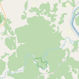
Карточка недвижимого имущества (кадастровый номер: 56540060121)
Кадастровый номер: 56540060121
Адрес: Dunavas pag., Jēkabpils nov.
Адрес: Dunavas pag., Jēkabpils nov.
Кадастровый номер недвижимого имущества | |
|---|---|
Вид недвижимого имущества | Вид недвижимого имущества: Недвижимость земли и сооружений |
Адрес | Адрес: Dunavas pag., Jēkabpils nov. |
Адрес | |
|---|---|
Идентификатор адреса | Идентификатор адреса: 100011662 |
Kомпании, зарегистрированные по адресу
| |
Подразделения, зарегистрированные по адресу
| |
Учреждения, зарегистрированные по адресу
| |
Недвижимость по адресу
| |
Сделки по адресу
|
|
|
|
{"7201070000":{"name":"<div class='color_dot' style='background-color: #00ff00'><\/div><span>\u0422\u0435\u0440\u0440\u0438\u0442\u043e\u0440\u0438\u0438 \u0441 \u043d\u0430\u0447\u0430\u0442\u044b\u043c \u0438\u0437\u043c\u0435\u0440\u0435\u043d\u0438\u0435\u043c \u0437\u0435\u043c\u043b\u0438<\/span>","featureColor":"#00ff00","features":{"type":"FeatureCollection","features":[{"type":"Feature","geometry":{"type":"Polygon","coordinates":[[[26.113561775,56.181284923],[26.114376436,56.17984848],[26.114447882,56.179851437],[26.115164299,56.179881058],[26.115226984,56.179892576],[26.115473112,56.179957626],[26.115732224,56.180053944],[26.1160725,56.18018979],[26.116294962,56.180337107],[26.11649527,56.180472715],[26.115644801,56.181319338],[26.115668975,56.181340196],[26.115005762,56.181579323],[26.11477321,56.181662235],[26.114596997,56.181725058],[26.114537717,56.181746194],[26.114547895,56.181765136],[26.114811763,56.181972328],[26.115032653,56.182244737],[26.11519373,56.18235519],[26.115547349,56.182351321],[26.115357516,56.182498749],[26.115168808,56.182620355],[26.114954035,56.182729844],[26.114805197,56.182891101],[26.114554751,56.182886156],[26.113936954,56.181903094],[26.113714118,56.18171967],[26.113565028,56.181288399],[26.113561775,56.181284923]]]},"crs":{"type":"name","properties":{"name":"urn:ogc:def:crs:EPSG:3059"}},"properties":{"style":{"color":"#00ff00","dashArray":"0","weight":1},"name":"\u0422\u0435\u0440\u0440\u0438\u0442\u043e\u0440\u0438\u0438 \u0441 \u043d\u0430\u0447\u0430\u0442\u044b\u043c \u0438\u0437\u043c\u0435\u0440\u0435\u043d\u0438\u0435\u043c \u0437\u0435\u043c\u043b\u0438","object_type":"SurveyingStatus","parcel_code":"56540060121","code":null,"surveyor":"B un B STRUKT\u016aRA SIA 30.04.2024.","address":"","ownership":"<span>\u0412\u043b\u0430\u0434\u0435\u043b\u0435\u0446 - \u0421\u0442pa\u043da<br>\u041f\u043e\u043b\u044c\u0437\u043e\u0432\u0430\u0442\u0435\u043b\u044c - \u042e\u0440\u0438\u0434\u0438\u0447\u0435\u0441\u043a\u043e\u0435 \u043b\u0438\u0446\u043e<br><\/span>","pro_cadastre_nr":"56540060121"}},{"type":"Feature","geometry":{"type":"Polygon","coordinates":[[[26.113561775,56.181284923],[26.114376436,56.17984848],[26.114447882,56.179851437],[26.115164299,56.179881058],[26.115226984,56.179892576],[26.115473112,56.179957626],[26.115732224,56.180053944],[26.1160725,56.18018979],[26.116294962,56.180337107],[26.11649527,56.180472715],[26.115644801,56.181319338],[26.115668975,56.181340196],[26.115005762,56.181579323],[26.11477321,56.181662235],[26.114596997,56.181725058],[26.114537717,56.181746194],[26.114547895,56.181765136],[26.114811763,56.181972328],[26.115032653,56.182244737],[26.11519373,56.18235519],[26.115547349,56.182351321],[26.115357516,56.182498749],[26.115168808,56.182620355],[26.114954035,56.182729844],[26.114805197,56.182891101],[26.114554751,56.182886156],[26.113936954,56.181903094],[26.113714118,56.18171967],[26.113565028,56.181288399],[26.113561775,56.181284923]]]},"crs":{"type":"name","properties":{"name":"urn:ogc:def:crs:EPSG:3059"}},"properties":{"style":{"color":"#00ff00","dashArray":"0","weight":1},"name":"\u0422\u0435\u0440\u0440\u0438\u0442\u043e\u0440\u0438\u0438 \u0441 \u043d\u0430\u0447\u0430\u0442\u044b\u043c \u0438\u0437\u043c\u0435\u0440\u0435\u043d\u0438\u0435\u043c \u0437\u0435\u043c\u043b\u0438","object_type":"SurveyingStatus","parcel_code":"56540060121","code":null,"surveyor":"B un B STRUKT\u016aRA SIA 30.04.2024.","address":"","ownership":"<span>\u0412\u043b\u0430\u0434\u0435\u043b\u0435\u0446 - \u0421\u0442pa\u043da<br>\u041f\u043e\u043b\u044c\u0437\u043e\u0432\u0430\u0442\u0435\u043b\u044c - \u042e\u0440\u0438\u0434\u0438\u0447\u0435\u0441\u043a\u043e\u0435 \u043b\u0438\u0446\u043e<br><\/span>","pro_cadastre_nr":"56540060121"}},{"type":"Feature","geometry":{"type":"Polygon","coordinates":[[[26.113561775,56.181284923],[26.114376436,56.17984848],[26.114447882,56.179851437],[26.115164299,56.179881058],[26.115226984,56.179892576],[26.115473112,56.179957626],[26.115732224,56.180053944],[26.1160725,56.18018979],[26.116294962,56.180337107],[26.11649527,56.180472715],[26.115644801,56.181319338],[26.115668975,56.181340196],[26.115005762,56.181579323],[26.11477321,56.181662235],[26.114596997,56.181725058],[26.114537717,56.181746194],[26.114547895,56.181765136],[26.114811763,56.181972328],[26.115032653,56.182244737],[26.11519373,56.18235519],[26.115547349,56.182351321],[26.115357516,56.182498749],[26.115168808,56.182620355],[26.114954035,56.182729844],[26.114805197,56.182891101],[26.114554751,56.182886156],[26.113936954,56.181903094],[26.113714118,56.18171967],[26.113565028,56.181288399],[26.113561775,56.181284923]]]},"crs":{"type":"name","properties":{"name":"urn:ogc:def:crs:EPSG:3059"}},"properties":{"style":{"color":"#00ff00","dashArray":"0","weight":1},"name":"\u0422\u0435\u0440\u0440\u0438\u0442\u043e\u0440\u0438\u0438 \u0441 \u043d\u0430\u0447\u0430\u0442\u044b\u043c \u0438\u0437\u043c\u0435\u0440\u0435\u043d\u0438\u0435\u043c \u0437\u0435\u043c\u043b\u0438","object_type":"SurveyingStatus","parcel_code":"56540060121","code":null,"surveyor":"B un B STRUKT\u016aRA SIA 30.04.2024.","address":"","ownership":"<span>\u0412\u043b\u0430\u0434\u0435\u043b\u0435\u0446 - \u0421\u0442pa\u043da<br>\u041f\u043e\u043b\u044c\u0437\u043e\u0432\u0430\u0442\u0435\u043b\u044c - \u042e\u0440\u0438\u0434\u0438\u0447\u0435\u0441\u043a\u043e\u0435 \u043b\u0438\u0446\u043e<br><\/span>","pro_cadastre_nr":"56540060121"}},{"type":"Feature","geometry":{"type":"Polygon","coordinates":[[[26.113561775,56.181284923],[26.114376436,56.17984848],[26.114447882,56.179851437],[26.115164299,56.179881058],[26.115226984,56.179892576],[26.115473112,56.179957626],[26.115732224,56.180053944],[26.1160725,56.18018979],[26.116294962,56.180337107],[26.11649527,56.180472715],[26.115644801,56.181319338],[26.115668975,56.181340196],[26.115005762,56.181579323],[26.11477321,56.181662235],[26.114596997,56.181725058],[26.114537717,56.181746194],[26.114547895,56.181765136],[26.114811763,56.181972328],[26.115032653,56.182244737],[26.11519373,56.18235519],[26.115547349,56.182351321],[26.115357516,56.182498749],[26.115168808,56.182620355],[26.114954035,56.182729844],[26.114805197,56.182891101],[26.114554751,56.182886156],[26.113936954,56.181903094],[26.113714118,56.18171967],[26.113565028,56.181288399],[26.113561775,56.181284923]]]},"crs":{"type":"name","properties":{"name":"urn:ogc:def:crs:EPSG:3059"}},"properties":{"style":{"color":"#00ff00","dashArray":"0","weight":1},"name":"\u0422\u0435\u0440\u0440\u0438\u0442\u043e\u0440\u0438\u0438 \u0441 \u043d\u0430\u0447\u0430\u0442\u044b\u043c \u0438\u0437\u043c\u0435\u0440\u0435\u043d\u0438\u0435\u043c \u0437\u0435\u043c\u043b\u0438","object_type":"SurveyingStatus","parcel_code":"56540060121","code":null,"surveyor":"B un B STRUKT\u016aRA SIA 30.04.2024.","address":"","ownership":"<span>\u0412\u043b\u0430\u0434\u0435\u043b\u0435\u0446 - \u0421\u0442pa\u043da<br>\u041f\u043e\u043b\u044c\u0437\u043e\u0432\u0430\u0442\u0435\u043b\u044c - \u042e\u0440\u0438\u0434\u0438\u0447\u0435\u0441\u043a\u043e\u0435 \u043b\u0438\u0446\u043e<br><\/span>","pro_cadastre_nr":"56540060121"}},{"type":"Feature","geometry":{"type":"Polygon","coordinates":[[[26.113561775,56.181284923],[26.114376436,56.17984848],[26.114447882,56.179851437],[26.115164299,56.179881058],[26.115226984,56.179892576],[26.115473112,56.179957626],[26.115732224,56.180053944],[26.1160725,56.18018979],[26.116294962,56.180337107],[26.11649527,56.180472715],[26.115644801,56.181319338],[26.115668975,56.181340196],[26.115005762,56.181579323],[26.11477321,56.181662235],[26.114596997,56.181725058],[26.114537717,56.181746194],[26.114547895,56.181765136],[26.114811763,56.181972328],[26.115032653,56.182244737],[26.11519373,56.18235519],[26.115547349,56.182351321],[26.115357516,56.182498749],[26.115168808,56.182620355],[26.114954035,56.182729844],[26.114805197,56.182891101],[26.114554751,56.182886156],[26.113936954,56.181903094],[26.113714118,56.18171967],[26.113565028,56.181288399],[26.113561775,56.181284923]]]},"crs":{"type":"name","properties":{"name":"urn:ogc:def:crs:EPSG:3059"}},"properties":{"style":{"color":"#00ff00","dashArray":"0","weight":1},"name":"\u0422\u0435\u0440\u0440\u0438\u0442\u043e\u0440\u0438\u0438 \u0441 \u043d\u0430\u0447\u0430\u0442\u044b\u043c \u0438\u0437\u043c\u0435\u0440\u0435\u043d\u0438\u0435\u043c \u0437\u0435\u043c\u043b\u0438","object_type":"SurveyingStatus","parcel_code":"56540060121","code":null,"surveyor":"B un B STRUKT\u016aRA SIA","address":"","ownership":"<span>\u0412\u043b\u0430\u0434\u0435\u043b\u0435\u0446 - \u0421\u0442pa\u043da<br>\u041f\u043e\u043b\u044c\u0437\u043e\u0432\u0430\u0442\u0435\u043b\u044c - \u042e\u0440\u0438\u0434\u0438\u0447\u0435\u0441\u043a\u043e\u0435 \u043b\u0438\u0446\u043e<br><\/span>","pro_cadastre_nr":"56540060121"}},{"type":"Feature","geometry":{"type":"Polygon","coordinates":[[[26.155766398,56.153911128],[26.155939207,56.154003951],[26.15784914,56.155029866],[26.157826553,56.155475951],[26.157513777,56.155739748],[26.157366914,56.15584482],[26.156740886,56.155101137],[26.156558572,56.154875597],[26.156183517,56.154393198],[26.155924546,56.154073372],[26.155766398,56.153911128]]]},"crs":{"type":"name","properties":{"name":"urn:ogc:def:crs:EPSG:3059"}},"properties":{"style":{"color":"#00ff00","dashArray":"0","weight":1},"name":"\u0422\u0435\u0440\u0440\u0438\u0442\u043e\u0440\u0438\u0438 \u0441 \u043d\u0430\u0447\u0430\u0442\u044b\u043c \u0438\u0437\u043c\u0435\u0440\u0435\u043d\u0438\u0435\u043c \u0437\u0435\u043c\u043b\u0438","object_type":"SurveyingStatus","parcel_code":"56540060080","code":null,"surveyor":"B un B STRUKT\u016aRA SIA 30.04.2024.","address":"","ownership":"<span>\u0412\u043b\u0430\u0434\u0435\u043b\u0435\u0446 - \u0421\u0442pa\u043da<br>\u041f\u043e\u043b\u044c\u0437\u043e\u0432\u0430\u0442\u0435\u043b\u044c - \u042e\u0440\u0438\u0434\u0438\u0447\u0435\u0441\u043a\u043e\u0435 \u043b\u0438\u0446\u043e<br><\/span>","pro_cadastre_nr":"56540060121"}},{"type":"Feature","geometry":{"type":"Polygon","coordinates":[[[26.155766398,56.153911128],[26.155939207,56.154003951],[26.15784914,56.155029866],[26.157826553,56.155475951],[26.157513777,56.155739748],[26.157366914,56.15584482],[26.156740886,56.155101137],[26.156558572,56.154875597],[26.156183517,56.154393198],[26.155924546,56.154073372],[26.155766398,56.153911128]]]},"crs":{"type":"name","properties":{"name":"urn:ogc:def:crs:EPSG:3059"}},"properties":{"style":{"color":"#00ff00","dashArray":"0","weight":1},"name":"\u0422\u0435\u0440\u0440\u0438\u0442\u043e\u0440\u0438\u0438 \u0441 \u043d\u0430\u0447\u0430\u0442\u044b\u043c \u0438\u0437\u043c\u0435\u0440\u0435\u043d\u0438\u0435\u043c \u0437\u0435\u043c\u043b\u0438","object_type":"SurveyingStatus","parcel_code":"56540060080","code":null,"surveyor":"B un B STRUKT\u016aRA SIA 30.04.2024.","address":"","ownership":"<span>\u0412\u043b\u0430\u0434\u0435\u043b\u0435\u0446 - \u0421\u0442pa\u043da<br>\u041f\u043e\u043b\u044c\u0437\u043e\u0432\u0430\u0442\u0435\u043b\u044c - \u042e\u0440\u0438\u0434\u0438\u0447\u0435\u0441\u043a\u043e\u0435 \u043b\u0438\u0446\u043e<br><\/span>","pro_cadastre_nr":"56540060121"}},{"type":"Feature","geometry":{"type":"Polygon","coordinates":[[[26.155766398,56.153911128],[26.155939207,56.154003951],[26.15784914,56.155029866],[26.157826553,56.155475951],[26.157513777,56.155739748],[26.157366914,56.15584482],[26.156740886,56.155101137],[26.156558572,56.154875597],[26.156183517,56.154393198],[26.155924546,56.154073372],[26.155766398,56.153911128]]]},"crs":{"type":"name","properties":{"name":"urn:ogc:def:crs:EPSG:3059"}},"properties":{"style":{"color":"#00ff00","dashArray":"0","weight":1},"name":"\u0422\u0435\u0440\u0440\u0438\u0442\u043e\u0440\u0438\u0438 \u0441 \u043d\u0430\u0447\u0430\u0442\u044b\u043c \u0438\u0437\u043c\u0435\u0440\u0435\u043d\u0438\u0435\u043c \u0437\u0435\u043c\u043b\u0438","object_type":"SurveyingStatus","parcel_code":"56540060080","code":null,"surveyor":"B un B STRUKT\u016aRA SIA","address":"","ownership":"<span>\u0412\u043b\u0430\u0434\u0435\u043b\u0435\u0446 - \u0421\u0442pa\u043da<br>\u041f\u043e\u043b\u044c\u0437\u043e\u0432\u0430\u0442\u0435\u043b\u044c - \u042e\u0440\u0438\u0434\u0438\u0447\u0435\u0441\u043a\u043e\u0435 \u043b\u0438\u0446\u043e<br><\/span>","pro_cadastre_nr":"56540060121"}},{"type":"Feature","geometry":{"type":"Polygon","coordinates":[[[26.155766398,56.153911128],[26.155939207,56.154003951],[26.15784914,56.155029866],[26.157826553,56.155475951],[26.157513777,56.155739748],[26.157366914,56.15584482],[26.156740886,56.155101137],[26.156558572,56.154875597],[26.156183517,56.154393198],[26.155924546,56.154073372],[26.155766398,56.153911128]]]},"crs":{"type":"name","properties":{"name":"urn:ogc:def:crs:EPSG:3059"}},"properties":{"style":{"color":"#00ff00","dashArray":"0","weight":1},"name":"\u0422\u0435\u0440\u0440\u0438\u0442\u043e\u0440\u0438\u0438 \u0441 \u043d\u0430\u0447\u0430\u0442\u044b\u043c \u0438\u0437\u043c\u0435\u0440\u0435\u043d\u0438\u0435\u043c \u0437\u0435\u043c\u043b\u0438","object_type":"SurveyingStatus","parcel_code":"56540060080","code":null,"surveyor":"B un B STRUKT\u016aRA SIA 30.04.2024.","address":"","ownership":"<span>\u0412\u043b\u0430\u0434\u0435\u043b\u0435\u0446 - \u0421\u0442pa\u043da<br>\u041f\u043e\u043b\u044c\u0437\u043e\u0432\u0430\u0442\u0435\u043b\u044c - \u042e\u0440\u0438\u0434\u0438\u0447\u0435\u0441\u043a\u043e\u0435 \u043b\u0438\u0446\u043e<br><\/span>","pro_cadastre_nr":"56540060121"}},{"type":"Feature","geometry":{"type":"Polygon","coordinates":[[[26.116350812,56.206550952],[26.118867026,56.205129882],[26.119574103,56.204890149],[26.119780125,56.204944421],[26.119934013,56.204944218],[26.121987156,56.204834289],[26.122703274,56.204807922],[26.123076546,56.2047822],[26.123622497,56.204754095],[26.12404254,56.204899497],[26.124725169,56.205183548],[26.126087912,56.205691064],[26.126809869,56.205995862],[26.12723406,56.206273919],[26.127446732,56.206377466],[26.12825952,56.206556168],[26.128492963,56.206641058],[26.128019697,56.206987628],[26.12797277,56.206991905],[26.125764009,56.205970342],[26.124065611,56.205731045],[26.121991582,56.205695436],[26.120540834,56.205670512],[26.120435671,56.205668702],[26.120034917,56.205966726],[26.119851384,56.206085455],[26.119763878,56.206150592],[26.119673996,56.206190202],[26.119543503,56.206220271],[26.118823919,56.206286626],[26.118581469,56.206319215],[26.118267725,56.206349611],[26.118138083,56.206339007],[26.118059594,56.206368301],[26.117778274,56.206393107],[26.117626163,56.206420085],[26.117503584,56.206454529],[26.117200165,56.206571631],[26.117116301,56.206615476],[26.117010098,56.206690215],[26.1169194,56.206721533],[26.116861922,56.20676463],[26.116811253,56.206743443],[26.116350812,56.206550952]]]},"crs":{"type":"name","properties":{"name":"urn:ogc:def:crs:EPSG:3059"}},"properties":{"style":{"color":"#00ff00","dashArray":"0","weight":1},"name":"\u0422\u0435\u0440\u0440\u0438\u0442\u043e\u0440\u0438\u0438 \u0441 \u043d\u0430\u0447\u0430\u0442\u044b\u043c \u0438\u0437\u043c\u0435\u0440\u0435\u043d\u0438\u0435\u043c \u0437\u0435\u043c\u043b\u0438","object_type":"SurveyingStatus","parcel_code":"56540020003","code":null,"surveyor":"B un B STRUKT\u016aRA SIA 30.04.2024.","address":"","ownership":"<span>\u0412\u043b\u0430\u0434\u0435\u043b\u0435\u0446 - \u0421\u0442pa\u043da<br>\u041f\u043e\u043b\u044c\u0437\u043e\u0432\u0430\u0442\u0435\u043b\u044c - \u042e\u0440\u0438\u0434\u0438\u0447\u0435\u0441\u043a\u043e\u0435 \u043b\u0438\u0446\u043e<br><\/span>","pro_cadastre_nr":"56540060121"}},{"type":"Feature","geometry":{"type":"Polygon","coordinates":[[[26.116350812,56.206550952],[26.118867026,56.205129882],[26.119574103,56.204890149],[26.119780125,56.204944421],[26.119934013,56.204944218],[26.121987156,56.204834289],[26.122703274,56.204807922],[26.123076546,56.2047822],[26.123622497,56.204754095],[26.12404254,56.204899497],[26.124725169,56.205183548],[26.126087912,56.205691064],[26.126809869,56.205995862],[26.12723406,56.206273919],[26.127446732,56.206377466],[26.12825952,56.206556168],[26.128492963,56.206641058],[26.128019697,56.206987628],[26.12797277,56.206991905],[26.125764009,56.205970342],[26.124065611,56.205731045],[26.121991582,56.205695436],[26.120540834,56.205670512],[26.120435671,56.205668702],[26.120034917,56.205966726],[26.119851384,56.206085455],[26.119763878,56.206150592],[26.119673996,56.206190202],[26.119543503,56.206220271],[26.118823919,56.206286626],[26.118581469,56.206319215],[26.118267725,56.206349611],[26.118138083,56.206339007],[26.118059594,56.206368301],[26.117778274,56.206393107],[26.117626163,56.206420085],[26.117503584,56.206454529],[26.117200165,56.206571631],[26.117116301,56.206615476],[26.117010098,56.206690215],[26.1169194,56.206721533],[26.116861922,56.20676463],[26.116811253,56.206743443],[26.116350812,56.206550952]]]},"crs":{"type":"name","properties":{"name":"urn:ogc:def:crs:EPSG:3059"}},"properties":{"style":{"color":"#00ff00","dashArray":"0","weight":1},"name":"\u0422\u0435\u0440\u0440\u0438\u0442\u043e\u0440\u0438\u0438 \u0441 \u043d\u0430\u0447\u0430\u0442\u044b\u043c \u0438\u0437\u043c\u0435\u0440\u0435\u043d\u0438\u0435\u043c \u0437\u0435\u043c\u043b\u0438","object_type":"SurveyingStatus","parcel_code":"56540020003","code":null,"surveyor":"B un B STRUKT\u016aRA SIA","address":"","ownership":"<span>\u0412\u043b\u0430\u0434\u0435\u043b\u0435\u0446 - \u0421\u0442pa\u043da<br>\u041f\u043e\u043b\u044c\u0437\u043e\u0432\u0430\u0442\u0435\u043b\u044c - \u042e\u0440\u0438\u0434\u0438\u0447\u0435\u0441\u043a\u043e\u0435 \u043b\u0438\u0446\u043e<br><\/span>","pro_cadastre_nr":"56540060121"}}]}},"7201060110":{"name":"<div class='color_dot' style='background-color: #00ffff'><\/div><span>\u0418\u0437\u043c\u0435\u0440\u0435\u043d\u043d\u0430\u044f \u0437\u0435\u043c\u0435\u043b\u044c\u043d\u0430\u044f \u0435\u0434\u0438\u043d\u0438\u0446\u0430<\/span>","featureColor":"#00ffff","features":{"type":"FeatureCollection","features":[{"type":"Feature","geometry":{"type":"Polygon","coordinates":[[[26.114554751,56.182886156],[26.113936954,56.181903094],[26.113714118,56.18171967],[26.113737948,56.181674193],[26.113603058,56.181264409],[26.114363057,56.179796522],[26.114424736,56.179801775],[26.114933889,56.179845126],[26.114927858,56.179857927],[26.115473249,56.179937853],[26.115697894,56.179991695],[26.115993216,56.180127573],[26.116118573,56.180177597],[26.116307704,56.180298694],[26.116367829,56.180394544],[26.11646099,56.180506832],[26.116425275,56.180542403],[26.115644801,56.181319338],[26.115668975,56.181340196],[26.115005762,56.181579323],[26.11477321,56.181662235],[26.114596997,56.181725058],[26.114537717,56.181746194],[26.114547895,56.181765136],[26.114811763,56.181972328],[26.115032653,56.182244737],[26.11519373,56.18235519],[26.115233513,56.182381497],[26.115246562,56.182423315],[26.115125569,56.182513368],[26.115073817,56.182528139],[26.115005182,56.182558215],[26.114825922,56.182654163],[26.114750852,56.182756803],[26.114667068,56.182851019],[26.114554751,56.182886156]]]},"crs":{"type":"name","properties":{"name":"urn:ogc:def:crs:EPSG:3059"}},"properties":{"style":{"color":"#00ffff","dashArray":"0","weight":1},"name":"\u0417\u0435\u043c\u043b\u044f","object_type":"Parcel","parcel_code":"56540060121","code":null,"surveyor":null,"address":"","ownership":"<span>\u0412\u043b\u0430\u0434\u0435\u043b\u0435\u0446 - \u0421\u0442pa\u043da<br>\u041f\u043e\u043b\u044c\u0437\u043e\u0432\u0430\u0442\u0435\u043b\u044c - \u042e\u0440\u0438\u0434\u0438\u0447\u0435\u0441\u043a\u043e\u0435 \u043b\u0438\u0446\u043e<br><\/span>","pro_cadastre_nr":"56540060121"}},{"type":"Feature","geometry":{"type":"Polygon","coordinates":[[[26.155939207,56.154003951],[26.157730846,56.154966335],[26.157781251,56.154993396],[26.157893275,56.155278794],[26.157881555,56.155358113],[26.157809561,56.155439706],[26.15779117,56.155478438],[26.157509416,56.155761349],[26.157450537,56.155801723],[26.157393414,56.155775777],[26.157272329,56.155673416],[26.156482849,56.154730338],[26.156112861,56.154224233],[26.155939207,56.154003951]]]},"crs":{"type":"name","properties":{"name":"urn:ogc:def:crs:EPSG:3059"}},"properties":{"style":{"color":"#00ffff","dashArray":"0","weight":1},"name":"\u0417\u0435\u043c\u043b\u044f","object_type":"Parcel","parcel_code":"56540060080","code":null,"surveyor":null,"address":"","ownership":"<span>\u0412\u043b\u0430\u0434\u0435\u043b\u0435\u0446 - \u0421\u0442pa\u043da<br>\u041f\u043e\u043b\u044c\u0437\u043e\u0432\u0430\u0442\u0435\u043b\u044c - \u042e\u0440\u0438\u0434\u0438\u0447\u0435\u0441\u043a\u043e\u0435 \u043b\u0438\u0446\u043e<br><\/span>","pro_cadastre_nr":"56540060121"}},{"type":"Feature","geometry":{"type":"Polygon","coordinates":[[[26.116350812,56.206550952],[26.119477003,56.204940622],[26.119574103,56.204890149],[26.119780125,56.204944421],[26.119934013,56.204944218],[26.121987156,56.204834289],[26.122703274,56.204807922],[26.123076546,56.2047822],[26.123622497,56.204754095],[26.12404254,56.204899497],[26.124725169,56.205183548],[26.126087912,56.205691064],[26.126809869,56.205995862],[26.12723406,56.206273919],[26.127446732,56.206377466],[26.12825952,56.206556168],[26.128492963,56.206641058],[26.128431752,56.206719283],[26.128373152,56.206744216],[26.128285769,56.206755767],[26.128241643,56.206787604],[26.128172409,56.2068057],[26.12814896,56.206844622],[26.128065864,56.206852945],[26.128026435,56.206918906],[26.128019697,56.206987628],[26.12797277,56.206991905],[26.125764009,56.205970342],[26.124065611,56.205731045],[26.121991582,56.205695436],[26.120540834,56.205670512],[26.120435671,56.205668702],[26.120034917,56.205966726],[26.119851384,56.206085455],[26.119763878,56.206150592],[26.119673996,56.206190202],[26.119543503,56.206220271],[26.118823919,56.206286626],[26.118581469,56.206319215],[26.118267725,56.206349611],[26.118138083,56.206339007],[26.118059594,56.206368301],[26.117778274,56.206393107],[26.117626163,56.206420085],[26.117503584,56.206454529],[26.117200165,56.206571631],[26.117116301,56.206615476],[26.117010098,56.206690215],[26.1169194,56.206721533],[26.116861922,56.20676463],[26.116811253,56.206743443],[26.116350812,56.206550952]]]},"crs":{"type":"name","properties":{"name":"urn:ogc:def:crs:EPSG:3059"}},"properties":{"style":{"color":"#00ffff","dashArray":"0","weight":1},"name":"\u0417\u0435\u043c\u043b\u044f","object_type":"Parcel","parcel_code":"56540020003","code":null,"surveyor":null,"address":"","ownership":"<span>\u0412\u043b\u0430\u0434\u0435\u043b\u0435\u0446 - \u0421\u0442pa\u043da<br>\u041f\u043e\u043b\u044c\u0437\u043e\u0432\u0430\u0442\u0435\u043b\u044c - \u042e\u0440\u0438\u0434\u0438\u0447\u0435\u0441\u043a\u043e\u0435 \u043b\u0438\u0446\u043e<br><\/span>","pro_cadastre_nr":"56540060121"}}]}}}
{"7201060310":{"name":"<div class='color_dot' style='background-color: #00ffff'><\/div><span>\u041f\u0440\u043e\u0435\u043a\u0442\u0438\u0440\u0443\u0435\u043c\u0430\u044f \u0437\u0435\u043c\u0435\u043b\u044c\u043d\u0430\u044f \u0435\u0434\u0438\u043d\u0438\u0446\u0430<\/span>","featureColor":"#00ffff","features":{"type":"FeatureCollection","features":[{"type":"Feature","geometry":{"type":"Polygon","coordinates":[[[26.113561775,56.181284923],[26.114376436,56.17984848],[26.114447882,56.179851437],[26.115164299,56.179881058],[26.115226984,56.179892576],[26.115473112,56.179957626],[26.115732224,56.180053944],[26.1160725,56.18018979],[26.116294962,56.180337107],[26.11649527,56.180472715],[26.115644801,56.181319338],[26.115668975,56.181340196],[26.115005762,56.181579323],[26.11477321,56.181662235],[26.114596997,56.181725058],[26.114537717,56.181746194],[26.114547895,56.181765136],[26.114811763,56.181972328],[26.115032653,56.182244737],[26.11519373,56.18235519],[26.115547349,56.182351321],[26.115357516,56.182498749],[26.115168808,56.182620355],[26.114954035,56.182729844],[26.114805197,56.182891101],[26.114554751,56.182886156],[26.113936954,56.181903094],[26.113714118,56.18171967],[26.113565028,56.181288399],[26.113561775,56.181284923]]]},"crs":{"type":"name","properties":{"name":"urn:ogc:def:crs:EPSG:3059"}},"properties":{"style":{"color":"#00ffff","dashArray":"2,4","weight":1},"name":"\u0417\u0435\u043c\u043b\u044f","object_type":"Parcel","parcel_code":"56540060121","code":null,"surveyor":null,"address":"","ownership":"<span>\u0412\u043b\u0430\u0434\u0435\u043b\u0435\u0446 - \u0421\u0442pa\u043da<br>\u041f\u043e\u043b\u044c\u0437\u043e\u0432\u0430\u0442\u0435\u043b\u044c - \u042e\u0440\u0438\u0434\u0438\u0447\u0435\u0441\u043a\u043e\u0435 \u043b\u0438\u0446\u043e<br><\/span>","pro_cadastre_nr":"56540060121"}},{"type":"Feature","geometry":{"type":"Polygon","coordinates":[[[26.155766398,56.153911128],[26.155939207,56.154003951],[26.15784914,56.155029866],[26.157826553,56.155475951],[26.157513777,56.155739748],[26.157366914,56.15584482],[26.156740886,56.155101137],[26.156558572,56.154875597],[26.156183517,56.154393198],[26.155924546,56.154073372],[26.155766398,56.153911128]]]},"crs":{"type":"name","properties":{"name":"urn:ogc:def:crs:EPSG:3059"}},"properties":{"style":{"color":"#00ffff","dashArray":"2,4","weight":1},"name":"\u0417\u0435\u043c\u043b\u044f","object_type":"Parcel","parcel_code":"56540060080","code":null,"surveyor":null,"address":"","ownership":"<span>\u0412\u043b\u0430\u0434\u0435\u043b\u0435\u0446 - \u0421\u0442pa\u043da<br>\u041f\u043e\u043b\u044c\u0437\u043e\u0432\u0430\u0442\u0435\u043b\u044c - \u042e\u0440\u0438\u0434\u0438\u0447\u0435\u0441\u043a\u043e\u0435 \u043b\u0438\u0446\u043e<br><\/span>","pro_cadastre_nr":"56540060121"}},{"type":"Feature","geometry":{"type":"Polygon","coordinates":[[[26.116350812,56.206550952],[26.118867026,56.205129882],[26.119574103,56.204890149],[26.119780125,56.204944421],[26.119934013,56.204944218],[26.121987156,56.204834289],[26.122703274,56.204807922],[26.123076546,56.2047822],[26.123622497,56.204754095],[26.12404254,56.204899497],[26.124725169,56.205183548],[26.126087912,56.205691064],[26.126809869,56.205995862],[26.12723406,56.206273919],[26.127446732,56.206377466],[26.12825952,56.206556168],[26.128492963,56.206641058],[26.128019697,56.206987628],[26.12797277,56.206991905],[26.125764009,56.205970342],[26.124065611,56.205731045],[26.121991582,56.205695436],[26.120540834,56.205670512],[26.120435671,56.205668702],[26.120034917,56.205966726],[26.119851384,56.206085455],[26.119763878,56.206150592],[26.119673996,56.206190202],[26.119543503,56.206220271],[26.118823919,56.206286626],[26.118581469,56.206319215],[26.118267725,56.206349611],[26.118138083,56.206339007],[26.118059594,56.206368301],[26.117778274,56.206393107],[26.117626163,56.206420085],[26.117503584,56.206454529],[26.117200165,56.206571631],[26.117116301,56.206615476],[26.117010098,56.206690215],[26.1169194,56.206721533],[26.116861922,56.20676463],[26.116811253,56.206743443],[26.116350812,56.206550952]]]},"crs":{"type":"name","properties":{"name":"urn:ogc:def:crs:EPSG:3059"}},"properties":{"style":{"color":"#00ffff","dashArray":"2,4","weight":1},"name":"\u0417\u0435\u043c\u043b\u044f","object_type":"Parcel","parcel_code":"56540020003","code":null,"surveyor":null,"address":"","ownership":"<span>\u0412\u043b\u0430\u0434\u0435\u043b\u0435\u0446 - \u0421\u0442pa\u043da<br>\u041f\u043e\u043b\u044c\u0437\u043e\u0432\u0430\u0442\u0435\u043b\u044c - \u042e\u0440\u0438\u0434\u0438\u0447\u0435\u0441\u043a\u043e\u0435 \u043b\u0438\u0446\u043e<br><\/span>","pro_cadastre_nr":"56540060121"}}]}}}
https://tile.openstreetmap.org/{z}/{x}/{y}.png|© OpenStreetMap contributors|minZoom: 7|maxZoom: 19
|
Данные о недвижимости обновлены: 29.12.2024.
Источник данных и лицензия: Открытые текстовые и пространственные данные Кадастровой информационной системы, Открытые данные Базы данных рынка недвижимости, Oткрытые данные Управления государственного строительного контроля, Открытые данные Минюста «Сведения о примененных санкциях в государственных реестрах», лицензия открытых данных Creative Commons Attribution , данные электронного аукциона судебной администрации, OpenStreetMap