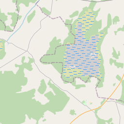
Карточка земельного участка (kадастровое обозначение:76480010093)
Кадастровое обозначение: 76480010093
Адрес: "Ilzītes", Gribolva, Galēnu pagasts, Preiļu novads, LV-5311
Кадастровое обозначение недвижимого имущества | |
|---|---|
Тип кадастрового объекта | Тип кадастрового объекта: Земельная единица |
Адрес | Адрес: "Ilzītes", Gribolva, Galēnu pagasts, Preiļu novads, LV-5311 |
Кадастровый номер недвижимого имущества, в которое входит данный земельный участок | Кадастровый номер недвижимого имущества, в которое входит данный земельный участок: 76480010093 |
Адрес | |
|---|---|
Идентификатор адреса | Идентификатор адреса: 103919792 |
Kомпании, зарегистрированные по адресу
| Kомпании, зарегистрированные по адресу
: 0 |
Подразделения, зарегистрированные по адресу
| Подразделения, зарегистрированные по адресу
: 0 |
Учреждения, зарегистрированные по адресу
| Учреждения, зарегистрированные по адресу
: 0 |
Недвижимость по адресу
| |
Сделки по адресу
| Сделки по адресу
: 0 |
|
|
|
{"7201060210":{"name":"<div class='color_dot' style='background-color: #00ffff'><\/div><span>\u0423\u043a\u0430\u0437\u0430\u043d\u043d\u0430\u044f \u0437\u0435\u043c\u0435\u043b\u044c\u043d\u0430\u044f \u0435\u0434\u0438\u043d\u0438\u0446\u0430<\/span>","featureColor":"#00ffff","features":{"type":"FeatureCollection","features":[{"type":"Feature","geometry":{"type":"Polygon","coordinates":[[[26.771375743,56.500251568],[26.772254224,56.499858326],[26.772343376,56.499818422],[26.772458091,56.500011994],[26.772661183,56.500287004],[26.772921526,56.500570379],[26.773181214,56.500850955],[26.773362471,56.500955062],[26.773782047,56.501148105],[26.774310878,56.501359647],[26.774836917,56.501562711],[26.775482913,56.501833244],[26.775574777,56.502000944],[26.775722528,56.502076073],[26.775634036,56.502131469],[26.774876678,56.502605565],[26.774482395,56.502271644],[26.773814408,56.501834009],[26.772552139,56.501099251],[26.771494487,56.500417115],[26.771375743,56.500251568]]]},"crs":{"type":"name","properties":{"name":"urn:ogc:def:crs:EPSG:3059"}},"properties":{"style":{"color":"#00ffff","dashArray":"8,12","weight":1},"name":"\u0417\u0435\u043c\u043b\u044f","object_type":"Parcel","parcel_code":"76480010093","code":null,"surveyor":null,"address":"\"Ilz\u012btes\", Gribolva, Gal\u0113nu pag., Prei\u013cu nov., LV-5311","ownership":"<span>\u0412\u043b\u0430\u0434\u0435\u043b\u0435\u0446 - \u0424\u0438\u0437\u0438\u0447\u0435\u0441\u043a\u043e\u0435 \u043b\u0438\u0446\u043e<br><\/span>","pro_cadastre_nr":"76480010093"}},{"type":"Feature","geometry":{"type":"Polygon","coordinates":[[[26.766887025,56.502311985],[26.768610102,56.501621979],[26.771204346,56.500361717],[26.772273553,56.501063309],[26.773616629,56.501927197],[26.774282141,56.502363216],[26.774751962,56.502689958],[26.772690115,56.504151103],[26.772023709,56.503804313],[26.771288096,56.503469815],[26.770132623,56.504085489],[26.766887025,56.502311985]]]},"crs":{"type":"name","properties":{"name":"urn:ogc:def:crs:EPSG:3059"}},"properties":{"style":{"color":"#00ffff","dashArray":"8,12","weight":1},"name":"\u0417\u0435\u043c\u043b\u044f","object_type":"Parcel","parcel_code":"76480010092","code":null,"surveyor":null,"address":"","ownership":"<span>\u0412\u043b\u0430\u0434\u0435\u043b\u0435\u0446 - \u0424\u0438\u0437\u0438\u0447\u0435\u0441\u043a\u043e\u0435 \u043b\u0438\u0446\u043e<br><\/span>","pro_cadastre_nr":"76480010093"}},{"type":"Feature","geometry":{"type":"Polygon","coordinates":[[[26.733309913,56.483849064],[26.733680927,56.483777543],[26.734153096,56.483805162],[26.736893397,56.484493977],[26.737536575,56.484756117],[26.738573909,56.485214013],[26.739971885,56.48566224],[26.740201324,56.485691824],[26.74038294,56.485668517],[26.740433015,56.485711408],[26.740715396,56.485953311],[26.740699411,56.486559104],[26.74069931,56.486648908],[26.740515008,56.486640448],[26.739221592,56.486581095],[26.738192045,56.486530991],[26.738086422,56.486509457],[26.737330958,56.486186276],[26.73655431,56.485861563],[26.735880773,56.485573239],[26.735198282,56.485277954],[26.735126044,56.485238973],[26.7346049,56.484881481],[26.734160423,56.484544705],[26.733309913,56.483849064]]]},"crs":{"type":"name","properties":{"name":"urn:ogc:def:crs:EPSG:3059"}},"properties":{"style":{"color":"#00ffff","dashArray":"8,12","weight":1},"name":"\u0417\u0435\u043c\u043b\u044f","object_type":"Parcel","parcel_code":"76480010086","code":null,"surveyor":null,"address":"","ownership":"<span>\u0412\u043b\u0430\u0434\u0435\u043b\u0435\u0446 - \u0424\u0438\u0437\u0438\u0447\u0435\u0441\u043a\u043e\u0435 \u043b\u0438\u0446\u043e<br><\/span>","pro_cadastre_nr":"76480010093"}}]}},"5201011310":{"name":"<div class='color_dot' style='background-color: #960096'><\/div><span>\u0412\u0435\u043a\u0442\u043e\u0440\u0438\u0437\u043e\u0432\u0430\u043d\u043d\u043e\u0435 \u0437\u0434\u0430\u043d\u0438\u0435<\/span>","featureColor":"#960096","features":{"type":"FeatureCollection","features":[{"type":"Feature","geometry":{"type":"Polygon","coordinates":[[[26.771569096,56.500444904],[26.771500545,56.500405043],[26.77162497,56.50033959],[26.77169352,56.500379441],[26.771569096,56.500444904]]]},"crs":{"type":"name","properties":{"name":"urn:ogc:def:crs:EPSG:3059"}},"properties":{"style":{"color":"#960096","dashArray":"0","weight":2},"name":"\u0417\u0434\u0430\u043d\u0438\u044f","object_type":"Building","parcel_code":"76480010093","code":"76480010093004","surveyor":null,"address":"\"Ilz\u012btes\", Gribolva, Gal\u0113nu pag., Prei\u013cu nov., LV-5311","ownership":"<span>\u0412\u043b\u0430\u0434\u0435\u043b\u0435\u0446 - \u0424\u0438\u0437\u0438\u0447\u0435\u0441\u043a\u043e\u0435 \u043b\u0438\u0446\u043e<br><\/span>","pro_cadastre_nr":"76480010093"}},{"type":"Feature","geometry":{"type":"Polygon","coordinates":[[[26.771968471,56.500474088],[26.772024817,56.500519722],[26.771853627,56.500584396],[26.771792049,56.500534537],[26.771830529,56.500519998],[26.771812635,56.500505522],[26.771904113,56.500470959],[26.771927224,56.500489669],[26.771968471,56.500474088]]]},"crs":{"type":"name","properties":{"name":"urn:ogc:def:crs:EPSG:3059"}},"properties":{"style":{"color":"#960096","dashArray":"0","weight":2},"name":"\u0417\u0434\u0430\u043d\u0438\u044f","object_type":"Building","parcel_code":"76480010093","code":"76480010093001","surveyor":null,"address":"\"Ilz\u012btes\", Gribolva, Gal\u0113nu pag., Prei\u013cu nov., LV-5311","ownership":"<span>\u0412\u043b\u0430\u0434\u0435\u043b\u0435\u0446 - \u0424\u0438\u0437\u0438\u0447\u0435\u0441\u043a\u043e\u0435 \u043b\u0438\u0446\u043e<br><\/span>","pro_cadastre_nr":"76480010093"}},{"type":"Feature","geometry":{"type":"Polygon","coordinates":[[[26.771780273,56.500115405],[26.771830867,56.500088937],[26.771859828,56.500105872],[26.771809236,56.500132348],[26.771780273,56.500115405]]]},"crs":{"type":"name","properties":{"name":"urn:ogc:def:crs:EPSG:3059"}},"properties":{"style":{"color":"#960096","dashArray":"0","weight":2},"name":"\u0417\u0434\u0430\u043d\u0438\u044f","object_type":"Building","parcel_code":"76480010093","code":"76480010093002","surveyor":null,"address":"\"Ilz\u012btes\", Gribolva, Gal\u0113nu pag., Prei\u013cu nov., LV-5311","ownership":"<span>\u0412\u043b\u0430\u0434\u0435\u043b\u0435\u0446 - \u0424\u0438\u0437\u0438\u0447\u0435\u0441\u043a\u043e\u0435 \u043b\u0438\u0446\u043e<br><\/span>","pro_cadastre_nr":"76480010093"}},{"type":"Feature","geometry":{"type":"Polygon","coordinates":[[[26.77169352,56.500379441],[26.77162497,56.50033959],[26.771704397,56.500297791],[26.771772948,56.500337652],[26.77169352,56.500379441]]]},"crs":{"type":"name","properties":{"name":"urn:ogc:def:crs:EPSG:3059"}},"properties":{"style":{"color":"#960096","dashArray":"0","weight":2},"name":"\u0417\u0434\u0430\u043d\u0438\u044f","object_type":"Building","parcel_code":"76480010093","code":"76480010093003","surveyor":null,"address":"\"Ilz\u012btes\", Gribolva, Gal\u0113nu pag., Prei\u013cu nov., LV-5311","ownership":"<span>\u0412\u043b\u0430\u0434\u0435\u043b\u0435\u0446 - \u0424\u0438\u0437\u0438\u0447\u0435\u0441\u043a\u043e\u0435 \u043b\u0438\u0446\u043e<br><\/span>","pro_cadastre_nr":"76480010093"}},{"type":"Feature","geometry":{"type":"Polygon","coordinates":[[[26.771039738,56.50059987],[26.771036577,56.500556554],[26.771104967,56.500555027],[26.771108129,56.500598343],[26.771039738,56.50059987]]]},"crs":{"type":"name","properties":{"name":"urn:ogc:def:crs:EPSG:3059"}},"properties":{"style":{"color":"#960096","dashArray":"0","weight":2},"name":"\u0417\u0434\u0430\u043d\u0438\u044f","object_type":"Building","parcel_code":"76480010092","code":"76480010092001","surveyor":null,"address":"","ownership":"<span>\u0412\u043b\u0430\u0434\u0435\u043b\u0435\u0446 - \u0424\u0438\u0437\u0438\u0447\u0435\u0441\u043a\u043e\u0435 \u043b\u0438\u0446\u043e<br><\/span>","pro_cadastre_nr":"76480010093"}},{"type":"Feature","geometry":{"type":"Polygon","coordinates":[[[26.771569096,56.500444904],[26.771500545,56.500405043],[26.77162497,56.50033959],[26.77169352,56.500379441],[26.771569096,56.500444904]]]},"crs":{"type":"name","properties":{"name":"urn:ogc:def:crs:EPSG:3059"}},"properties":{"style":{"color":"#960096","dashArray":"0","weight":2},"name":"\u0417\u0434\u0430\u043d\u0438\u044f","object_type":"Building","parcel_code":"76480010093","code":"76480010093004","surveyor":null,"address":"\"Ilz\u012btes\", Gribolva, Gal\u0113nu pag., Prei\u013cu nov., LV-5311","ownership":"<span>\u0412\u043b\u0430\u0434\u0435\u043b\u0435\u0446 - \u0424\u0438\u0437\u0438\u0447\u0435\u0441\u043a\u043e\u0435 \u043b\u0438\u0446\u043e<br><\/span>","pro_cadastre_nr":"76480010093"}},{"type":"Feature","geometry":{"type":"Polygon","coordinates":[[[26.77169352,56.500379441],[26.77162497,56.50033959],[26.771704397,56.500297791],[26.771772948,56.500337652],[26.77169352,56.500379441]]]},"crs":{"type":"name","properties":{"name":"urn:ogc:def:crs:EPSG:3059"}},"properties":{"style":{"color":"#960096","dashArray":"0","weight":2},"name":"\u0417\u0434\u0430\u043d\u0438\u044f","object_type":"Building","parcel_code":"76480010093","code":"76480010093003","surveyor":null,"address":"\"Ilz\u012btes\", Gribolva, Gal\u0113nu pag., Prei\u013cu nov., LV-5311","ownership":"<span>\u0412\u043b\u0430\u0434\u0435\u043b\u0435\u0446 - \u0424\u0438\u0437\u0438\u0447\u0435\u0441\u043a\u043e\u0435 \u043b\u0438\u0446\u043e<br><\/span>","pro_cadastre_nr":"76480010093"}},{"type":"Feature","geometry":{"type":"Polygon","coordinates":[[[26.771780273,56.500115405],[26.771830867,56.500088937],[26.771859828,56.500105872],[26.771809236,56.500132348],[26.771780273,56.500115405]]]},"crs":{"type":"name","properties":{"name":"urn:ogc:def:crs:EPSG:3059"}},"properties":{"style":{"color":"#960096","dashArray":"0","weight":2},"name":"\u0417\u0434\u0430\u043d\u0438\u044f","object_type":"Building","parcel_code":"76480010093","code":"76480010093002","surveyor":null,"address":"\"Ilz\u012btes\", Gribolva, Gal\u0113nu pag., Prei\u013cu nov., LV-5311","ownership":"<span>\u0412\u043b\u0430\u0434\u0435\u043b\u0435\u0446 - \u0424\u0438\u0437\u0438\u0447\u0435\u0441\u043a\u043e\u0435 \u043b\u0438\u0446\u043e<br><\/span>","pro_cadastre_nr":"76480010093"}},{"type":"Feature","geometry":{"type":"Polygon","coordinates":[[[26.771968471,56.500474088],[26.772024817,56.500519722],[26.771853627,56.500584396],[26.771792049,56.500534537],[26.771830529,56.500519998],[26.771812635,56.500505522],[26.771904113,56.500470959],[26.771927224,56.500489669],[26.771968471,56.500474088]]]},"crs":{"type":"name","properties":{"name":"urn:ogc:def:crs:EPSG:3059"}},"properties":{"style":{"color":"#960096","dashArray":"0","weight":2},"name":"\u0417\u0434\u0430\u043d\u0438\u044f","object_type":"Building","parcel_code":"76480010093","code":"76480010093001","surveyor":null,"address":"\"Ilz\u012btes\", Gribolva, Gal\u0113nu pag., Prei\u013cu nov., LV-5311","ownership":"<span>\u0412\u043b\u0430\u0434\u0435\u043b\u0435\u0446 - \u0424\u0438\u0437\u0438\u0447\u0435\u0441\u043a\u043e\u0435 \u043b\u0438\u0446\u043e<br><\/span>","pro_cadastre_nr":"76480010093"}},{"type":"Feature","geometry":{"type":"Polygon","coordinates":[[[26.771039738,56.50059987],[26.771036577,56.500556554],[26.771104967,56.500555027],[26.771108129,56.500598343],[26.771039738,56.50059987]]]},"crs":{"type":"name","properties":{"name":"urn:ogc:def:crs:EPSG:3059"}},"properties":{"style":{"color":"#960096","dashArray":"0","weight":2},"name":"\u0417\u0434\u0430\u043d\u0438\u044f","object_type":"Building","parcel_code":"76480010092","code":"76480010092001","surveyor":null,"address":"\"Ilz\u012btes\", Gribolva, Gal\u0113nu pag., Prei\u013cu nov., LV-5311","ownership":"<span>\u0412\u043b\u0430\u0434\u0435\u043b\u0435\u0446 - \u0424\u0438\u0437\u0438\u0447\u0435\u0441\u043a\u043e\u0435 \u043b\u0438\u0446\u043e<br><\/span>","pro_cadastre_nr":"76480010093"}}]}}}
[]
https://tile.openstreetmap.org/{z}/{x}/{y}.png|© OpenStreetMap contributors|minZoom: 7|maxZoom: 19
|
Обновлены данные о земельных единицах: 10.01.2025.
Источник данных и лицензия: открытые текстовые и пространственные данные кадастровой информационной системы, открытые данные базы данных рынка недвижимости, лицензия на открытые данные Creative Commons Attribution, OpenStreetMap

