Deal ID: 905616
Transaction object type | Transaction object type: The land |
|---|---|
Object | Object: Land |
Property cadastral number | |
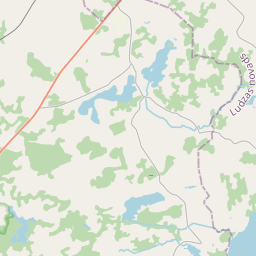
Address record | Address record: "Steponi", Dzērves, Mežvidu pag., Ludzas nov., LV-5725 |
Transaction date | Transaction date: |
Address | |
|---|---|
Address ID | Address ID: 105918644 |
Companies registered at the address | Companies registered at the address: 0 |
Departments registered at the address | Departments registered at the address: 0 |
Institutions registered at the address | Institutions registered at the address: 0 |
Real estate registered at the address | |
Transactions with real estate at the address |
|
{"7201060210":{"name":"<div class='color_dot' style='background-color: #00ffff'><\/div><span>Specified land unit<\/span>","featureColor":"#00ffff","features":{"type":"FeatureCollection","features":[{"type":"Feature","geometry":{"type":"Polygon","coordinates":[[[27.598634154,56.628677959],[27.598787951,56.628428087],[27.599101834,56.627946485],[27.599394919,56.627448868],[27.599515448,56.62745249],[27.602402985,56.627382122],[27.604754264,56.627358178],[27.607662765,56.627305718],[27.609747578,56.627264759],[27.613309998,56.627229436],[27.617691281,56.627287427],[27.617819768,56.627289127],[27.617813282,56.627401408],[27.617785107,56.627442571],[27.617746898,56.627482003],[27.617661684,56.627558957],[27.61761556,56.627611476],[27.617610203,56.62763099],[27.617615784,56.627651615],[27.617636145,56.627694225],[27.617637576,56.62772211],[27.617627616,56.627737334],[27.617591634,56.627760346],[27.617544164,56.627775817],[27.617459915,56.627791845],[27.617373624,56.627797287],[27.617317205,56.627794443],[27.617232629,56.627782527],[27.617152589,56.627761443],[27.617105042,56.62774052],[27.617068011,56.627716809],[27.616975808,56.627642132],[27.616892713,56.62758948],[27.616803142,56.62754499],[27.616775884,56.627541234],[27.616744755,56.627546797],[27.61668591,56.627572435],[27.616620041,56.627614829],[27.616568214,56.627658388],[27.616541791,56.627688909],[27.616517091,56.62773247],[27.616500891,56.627803314],[27.616506845,56.627875025],[27.616521444,56.627922379],[27.616552076,56.62798385],[27.616574313,56.628016596],[27.616605886,56.628047012],[27.61663614,56.628065525],[27.616696307,56.628090991],[27.616759067,56.628109467],[27.616893441,56.628136154],[27.6170542,56.628163439],[27.617107538,56.628167669],[27.6171753,56.628164618],[27.617211351,56.62815696],[27.617387553,56.628100584],[27.617559473,56.628038667],[27.617762692,56.627963089],[27.617776996,56.627963078],[27.617950525,56.628027286],[27.617980982,56.628033098],[27.618014916,56.628031957],[27.618087055,56.628022503],[27.618133354,56.628021874],[27.618157491,56.628027277],[27.618205352,56.628046869],[27.618247286,56.628068953],[27.61831675,56.628119431],[27.61835517,56.628156767],[27.618388872,56.62820138],[27.618412048,56.628247657],[27.61822013,56.628287949],[27.612754692,56.628344729],[27.610651385,56.628374398],[27.60875998,56.628366429],[27.60338962,56.628440104],[27.59869464,56.628694046],[27.598634154,56.628677959]]]},"crs":{"type":"name","properties":{"name":"urn:ogc:def:crs:EPSG:3059"}},"properties":{"style":{"color":"#00ffff","dashArray":"8,12","weight":1},"name":"Land","object_type":"Parcel","parcel_code":"68700110018","code":null,"surveyor":null,"address":"\"Steponi\", Dz\u0113rves, Me\u017evidu pag., Ludzas nov., LV-5725","ownership":"<span>Owner - Legal entity<br><\/span>","pro_cadastre_nr":"68700110018"}}]}},"7114100000":{"name":"<div class='color_dot' style='background-color: #b40000'><\/div><span>Burdened access road servitude area<\/span>","featureColor":"#b40000","features":{"type":"FeatureCollection","features":[{"type":"Feature","geometry":{"type":"Polygon","coordinates":[[[27.59951898,56.627454456],[27.599556858,56.627452433],[27.599140372,56.627949325],[27.598826689,56.628430625],[27.598672893,56.628680497],[27.598642035,56.628674728],[27.598795832,56.628424856],[27.599109714,56.627943254],[27.59951898,56.627454456]]]},"crs":{"type":"name","properties":{"name":"urn:ogc:def:crs:EPSG:3059"}},"properties":{"style":{"color":"#b40000","dashArray":"4,2,1,2","weight":1},"name":"Burdened access road servitude area","object_type":"WayRestriction","parcel_code":"68700110018","code":"7315030100001","surveyor":null,"address":"\"Steponi\", Dz\u0113rves, Me\u017evidu pag., Ludzas nov., LV-5725","ownership":"<span>Owner - Legal entity<br><\/span>","pro_cadastre_nr":"68700110018"}}]}},"5201011310":{"name":"<div class='color_dot' style='background-color: #960096'><\/div><span>Vectorized building<\/span>","featureColor":"#960096","features":{"type":"FeatureCollection","features":[{"type":"Feature","geometry":{"type":"Polygon","coordinates":[[[27.607698144,56.627914124],[27.607694433,56.627859395],[27.60786371,56.627855894],[27.607867438,56.627910631],[27.607698144,56.627914124]]]},"crs":{"type":"name","properties":{"name":"urn:ogc:def:crs:EPSG:3059"}},"properties":{"style":{"color":"#960096","dashArray":"0","weight":2},"name":"Building","object_type":"Building","parcel_code":"68700110018","code":"68700110018001","surveyor":null,"address":"\"Steponi\", Dz\u0113rves, Me\u017evidu pag., Ludzas nov., LV-5725","ownership":null,"pro_cadastre_nr":null}}]}}}
{"7201060210":{"name":"<div class='color_dot' style='background-color: #00ffff'><\/div><span>Specified land unit<\/span>","featureColor":"#00ffff","features":{"type":"FeatureCollection","features":[{"type":"Feature","geometry":{"type":"Polygon","coordinates":[[[27.598634154,56.628677959],[27.598787951,56.628428087],[27.599101834,56.627946485],[27.599515448,56.62745249],[27.602402985,56.627382122],[27.604754264,56.627358178],[27.607662765,56.627305718],[27.609747578,56.627264759],[27.613309998,56.627229436],[27.617691281,56.627287427],[27.617819768,56.627289127],[27.617813282,56.627401408],[27.617785107,56.627442571],[27.617746898,56.627482003],[27.617661684,56.627558957],[27.61761556,56.627611476],[27.617610203,56.62763099],[27.617615784,56.627651615],[27.617636145,56.627694225],[27.617637576,56.62772211],[27.617627616,56.627737334],[27.617591634,56.627760346],[27.617544164,56.627775817],[27.617459915,56.627791845],[27.617373624,56.627797287],[27.617317205,56.627794443],[27.617232629,56.627782527],[27.617152589,56.627761443],[27.617105042,56.62774052],[27.617068011,56.627716809],[27.616975808,56.627642132],[27.616892713,56.62758948],[27.616803142,56.62754499],[27.616775884,56.627541234],[27.616744755,56.627546797],[27.61668591,56.627572435],[27.616620041,56.627614829],[27.616568214,56.627658388],[27.616541791,56.627688909],[27.616517091,56.62773247],[27.616500891,56.627803314],[27.616506845,56.627875025],[27.616521444,56.627922379],[27.616552076,56.62798385],[27.616574313,56.628016596],[27.616605886,56.628047012],[27.61663614,56.628065525],[27.616696307,56.628090991],[27.616759067,56.628109467],[27.616893441,56.628136154],[27.6170542,56.628163439],[27.617107538,56.628167669],[27.6171753,56.628164618],[27.617211351,56.62815696],[27.617387553,56.628100584],[27.617559473,56.628038667],[27.617762692,56.627963089],[27.617776996,56.627963078],[27.617950525,56.628027286],[27.617980982,56.628033098],[27.618014916,56.628031957],[27.618087055,56.628022503],[27.618133354,56.628021874],[27.618157491,56.628027277],[27.618205352,56.628046869],[27.618247286,56.628068953],[27.61831675,56.628119431],[27.61835517,56.628156767],[27.618388872,56.62820138],[27.618412048,56.628247657],[27.61822013,56.628287949],[27.612754692,56.628344729],[27.610651385,56.628374398],[27.60875998,56.628366429],[27.60338962,56.628440104],[27.59869464,56.628694046],[27.598634154,56.628677959]]]},"crs":{"type":"name","properties":{"name":"urn:ogc:def:crs:EPSG:3059"}},"properties":{"style":{"color":"#00ffff","dashArray":"8,12","weight":1},"name":"Land","object_type":"Parcel","parcel_code":"68700110018","code":null,"surveyor":null,"address":"\"Steponi\", Dz\u0113rves, Me\u017evidu pag., Ludzas nov., LV-5725","ownership":"<span>Owner - Legal entity<br><\/span>","pro_cadastre_nr":"68700110018"}}]}}}
https://tile.openstreetmap.org/{z}/{x}/{y}.png|© OpenStreetMap contributors|minZoom: 7|maxZoom: 19
|
Data source and license: Open data of the real estate market database, Open data of the cadastral information system, open data license: Creative Commons Attribution, OpenStreetMap


