Deal ID: 1220333
Transaction object type | Transaction object type: The land |
|---|---|
Object | Object: Land |
Property cadastral number | |
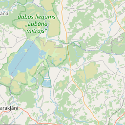
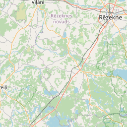
Administrative area | Administrative area: Sokolku pag., Rēzeknes nov. |
Transaction date | Transaction date: |
Administrative area | |
|---|---|
Address ID | Address ID: 100013512 |
Companies registered at the address | |
Departments registered at the address | |
Institutions registered at the address | |
Real estate registered at the address | |
Transactions with real estate at the address |
|
{"7201060110":{"name":"<div class='color_dot' style='background-color: #00ffff'><\/div><span>Measured land unit<\/span>","featureColor":"#00ffff","features":{"type":"FeatureCollection","features":[{"type":"Feature","geometry":{"type":"Polygon","coordinates":[[[27.039748054,56.471978492],[27.039997699,56.47180897],[27.040226751,56.471628508],[27.040453475,56.471432993],[27.040473575,56.471451395],[27.04217422,56.473008487],[27.0438506,56.474551231],[27.04149742,56.474879479],[27.040918867,56.473775307],[27.039772176,56.472015503],[27.039748054,56.471978492]]]},"crs":{"type":"name","properties":{"name":"urn:ogc:def:crs:EPSG:3059"}},"properties":{"style":{"color":"#00ffff","dashArray":"0","weight":1},"name":"Land","object_type":"Parcel","parcel_code":"78900050290","code":null,"surveyor":null,"address":"","ownership":"<span>Owner - Legal entity<br><\/span>","pro_cadastre_nr":"78900040031"}},{"type":"Feature","geometry":{"type":"Polygon","coordinates":[[[27.04146223,56.467360243],[27.041533803,56.467347135],[27.042405915,56.46718746],[27.043216173,56.46827982],[27.044858081,56.467810477],[27.046405406,56.467300232],[27.045782094,56.466465607],[27.048918687,56.465851766],[27.048682428,56.466611238],[27.048786928,56.466689626],[27.048486175,56.467940532],[27.048476271,56.467981047],[27.046828129,56.468730786],[27.048420466,56.469567308],[27.048462036,56.469618064],[27.048310497,56.469625348],[27.047255542,56.469805763],[27.046471301,56.469846534],[27.04621619,56.46984381],[27.04566717,56.469812595],[27.04541028,56.469751779],[27.043720288,56.469225549],[27.042880928,56.46875399],[27.042442371,56.468533643],[27.042135127,56.468301867],[27.04146223,56.467360243]]]},"crs":{"type":"name","properties":{"name":"urn:ogc:def:crs:EPSG:3059"}},"properties":{"style":{"color":"#00ffff","dashArray":"0","weight":1},"name":"Land","object_type":"Parcel","parcel_code":"78900050272","code":null,"surveyor":null,"address":"","ownership":"<span>Owner - Legal entity<br><\/span>","pro_cadastre_nr":"78900040031"}},{"type":"Feature","geometry":{"type":"Polygon","coordinates":[[[26.952216652,56.465112259],[26.952830685,56.463535947],[26.953347561,56.463154477],[26.953664695,56.462855101],[26.954303878,56.461862803],[26.954417319,56.46159864],[26.954735174,56.461502916],[26.955108289,56.461497569],[26.955582653,56.461465486],[26.955588357,56.461499598],[26.956698106,56.461731387],[26.958634404,56.462172493],[26.960668846,56.462636064],[26.963310427,56.460228259],[26.963388691,56.460200241],[26.963732844,56.460322772],[26.964977378,56.460738956],[26.967453618,56.461543593],[26.96864897,56.461949538],[26.96891403,56.462038316],[26.969046256,56.462122461],[26.969062013,56.462256874],[26.968832294,56.462952814],[26.968453346,56.464082546],[26.968236824,56.464754573],[26.9682256,56.464932967],[26.968284552,56.465013365],[26.968149461,56.464982062],[26.967467412,56.464823993],[26.964092604,56.463659227],[26.960367057,56.465197708],[26.965314407,56.467173114],[26.966367527,56.467593565],[26.969335095,56.465958116],[26.969436878,56.465902016],[26.969647247,56.466009738],[26.969902778,56.466222448],[26.970121966,56.466503491],[26.970309335,56.466748224],[26.970471079,56.466878826],[26.970399868,56.466902878],[26.970360764,56.466924686],[26.969957726,56.467149433],[26.969647366,56.467490479],[26.969147262,56.467950432],[26.968326391,56.468623986],[26.968325338,56.468624847],[26.967161925,56.469579421],[26.967067985,56.469612391],[26.966734414,56.469729449],[26.966285007,56.469865106],[26.965477449,56.470108883],[26.963886322,56.470569565],[26.963292686,56.4707263],[26.961673639,56.470775351],[26.959933,56.470815039],[26.959521797,56.470825666],[26.958973258,56.470872081],[26.958834749,56.470880688],[26.958871866,56.470743099],[26.959091339,56.470542454],[26.956053665,56.469253271],[26.955555563,56.469009709],[26.954145611,56.46711407],[26.953647828,56.466652557],[26.952248168,56.465296456],[26.952216652,56.465112259]]]},"crs":{"type":"name","properties":{"name":"urn:ogc:def:crs:EPSG:3059"}},"properties":{"style":{"color":"#00ffff","dashArray":"0","weight":1},"name":"Land","object_type":"Parcel","parcel_code":"78900040199","code":null,"surveyor":null,"address":"","ownership":"<span>Owner - Legal entity<br><\/span>","pro_cadastre_nr":"78900040031"}},{"type":"Feature","geometry":{"type":"Polygon","coordinates":[[[26.973034594,56.464677503],[26.973525459,56.462229364],[26.976076291,56.463020998],[26.975505973,56.463453871],[26.975835551,56.463596747],[26.976474897,56.463144444],[26.978617703,56.463809121],[26.980116121,56.464665706],[26.978015819,56.466187209],[26.973034594,56.464677503]]]},"crs":{"type":"name","properties":{"name":"urn:ogc:def:crs:EPSG:3059"}},"properties":{"style":{"color":"#00ffff","dashArray":"0","weight":1},"name":"Land","object_type":"Parcel","parcel_code":"78900040031","code":null,"surveyor":null,"address":"","ownership":"<span>Owner - Legal entity<br><\/span>","pro_cadastre_nr":"78900040031"}}]}},"7114100000":{"name":"<div class='color_dot' style='background-color: #b40000'><\/div><span>Burdened access road servitude area<\/span>","featureColor":"#b40000","features":{"type":"FeatureCollection","features":[{"type":"Feature","geometry":{"type":"Polygon","coordinates":[[[27.040226557,56.47162934],[27.040453464,56.471433065],[27.040473207,56.471451252],[27.040474096,56.471452021],[27.04046541,56.471460782],[27.040155394,56.471720562],[27.04008021,56.471779801],[27.039903733,56.471905479],[27.039762486,56.47199974],[27.039748249,56.471978497],[27.039997522,56.471809801],[27.040226557,56.47162934]]]},"crs":{"type":"name","properties":{"name":"urn:ogc:def:crs:EPSG:3059"}},"properties":{"style":{"color":"#b40000","dashArray":"4,2,1,2","weight":1},"name":"Burdened access road servitude area","object_type":"WayRestriction","parcel_code":"78900050290","code":"7315030100002","surveyor":null,"address":"","ownership":"<span>Owner - Legal entity<br><\/span>","pro_cadastre_nr":"78900040031"}}]}}}
{"7201060110":{"name":"<div class='color_dot' style='background-color: #00ffff'><\/div><span>Measured land unit<\/span>","featureColor":"#00ffff","features":{"type":"FeatureCollection","features":[{"type":"Feature","geometry":{"type":"Polygon","coordinates":[[[27.04146223,56.467360243],[27.041533803,56.467347135],[27.042405947,56.467187459],[27.043216141,56.468279821],[27.044858145,56.467810467],[27.046405406,56.467300232],[27.045782094,56.466465607],[27.048918687,56.465851766],[27.048682428,56.466611238],[27.048786928,56.466689626],[27.048486245,56.467940189],[27.04847643,56.467981008],[27.046828067,56.468730814],[27.048420479,56.469567263],[27.048462036,56.469618064],[27.048310497,56.469625348],[27.047255542,56.469805763],[27.046471301,56.469846534],[27.04621619,56.46984381],[27.04566717,56.469812595],[27.04541028,56.469751779],[27.043720288,56.469225549],[27.042880928,56.46875399],[27.042442371,56.468533643],[27.042135127,56.468301867],[27.04146223,56.467360243]]]},"crs":{"type":"name","properties":{"name":"urn:ogc:def:crs:EPSG:3059"}},"properties":{"style":{"color":"#00ffff","dashArray":"0","weight":1},"name":"Land","object_type":"Parcel","parcel_code":"78900050272","code":null,"surveyor":null,"address":"","ownership":"<span>Owner - Legal entity<br><\/span>","pro_cadastre_nr":"78900040031"}}]}}}
https://tile.openstreetmap.org/{z}/{x}/{y}.png|© OpenStreetMap contributors|minZoom: 7|maxZoom: 19
|
Data source and license: Open data of the real estate market database, Open data of the cadastral information system, open data license: Creative Commons Attribution, OpenStreetMap