Deal ID: 1172498
Transaction object type | Transaction object type: The land |
|---|---|
Object | Object: Land |
Property cadastral number | |
Administrative area | Administrative area: Mežvidu pag., Ludzas nov. |
Transaction date | Transaction date: |
Administrative area | |
|---|---|
Address ID | Address ID: 100012672 |
Companies registered at the address | |
Departments registered at the address | |
Institutions registered at the address | |
Real estate registered at the address | |
Transactions with real estate at the address |
|
{"7201060210":{"name":"<div class='color_dot' style='background-color: #00ffff'><\/div><span>Specified land unit<\/span>","featureColor":"#00ffff","features":{"type":"FeatureCollection","features":[{"type":"Feature","geometry":{"type":"Polygon","coordinates":[[[27.516642807,56.681553672],[27.519585186,56.68041598],[27.520245315,56.680519909],[27.520274075,56.680532456],[27.520051464,56.680724583],[27.520000856,56.680920258],[27.520171475,56.681231831],[27.520725654,56.681868559],[27.521294378,56.682335021],[27.521841932,56.682712012],[27.521919073,56.682965559],[27.521818364,56.683156252],[27.52080043,56.682870145],[27.518477241,56.682035224],[27.517950268,56.681838539],[27.516642807,56.681553672]]]},"crs":{"type":"name","properties":{"name":"urn:ogc:def:crs:EPSG:3059"}},"properties":{"style":{"color":"#00ffff","dashArray":"8,12","weight":1},"name":"Land","object_type":"Parcel","parcel_code":"68700060112","code":null,"surveyor":null,"address":"","ownership":"<span>Owner - Legal entity<br><\/span>","pro_cadastre_nr":"68700030050"}},{"type":"Feature","geometry":{"type":"Polygon","coordinates":[[[27.541147541,56.712086553],[27.54137803,56.712008168],[27.542875205,56.711554578],[27.546129981,56.710491736],[27.546337083,56.710633166],[27.547181037,56.711513067],[27.547184788,56.711575257],[27.551879676,56.715051771],[27.548195053,56.714668684],[27.547567245,56.714641085],[27.546633774,56.71463638],[27.541841344,56.714406787],[27.54140925,56.71442132],[27.541423904,56.714270002],[27.541187382,56.712223517],[27.541157955,56.712122363],[27.541147541,56.712086553]]]},"crs":{"type":"name","properties":{"name":"urn:ogc:def:crs:EPSG:3059"}},"properties":{"style":{"color":"#00ffff","dashArray":"8,12","weight":1},"name":"Land","object_type":"Parcel","parcel_code":"68700030050","code":null,"surveyor":null,"address":"","ownership":"<span>Owner - Legal entity<br><\/span>","pro_cadastre_nr":"68700030050"}}]}}}
[]
https://tile.openstreetmap.org/{z}/{x}/{y}.png|© OpenStreetMap contributors|minZoom: 7|maxZoom: 19
|
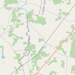
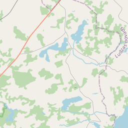
Data source and license: Open data of the real estate market database, Open data of the cadastral information system, open data license: Creative Commons Attribution, OpenStreetMap